| The Domesday Book & Stoke-on-Trent | |
The Domesday Book & Stoke-on-Trent
On this page are an extracts of the 1087 Domesday Book as far as they are relevant to the Stoke-on-Trent area of North Staffordshire.
Of the principle six towns of the city only Burslem and Fenton are in existence at the time. Included in the description of Caverswall is a mention of a church at Stoke but no description of any land or settlement, presumably the church served nearby Penkull.
In the tables below the heading in the blue section is not part of the Domesday Book [but the spelling as used is included].
'Land of the King.....'
| BUCKNALL [BVCHENOLE] (17 on the Pirehill map) |
|
In
BUCKNALL the third part of a hide. Ketel held it. |
|
ENDON [ENEDVN] (6 on the Totmonslow map) |
| ENDON land for 1, or 2 ploughs. Dunning held it. |
|
PENKHULL [PINCHETEL] (18 on the Pirehill map) |
|
PENKHULL. Earl Algar held it. 2 hides, with its dependencies. |
| TRENTHAM [TRENHAM] (25 on the Pirehill map) |
|
TRENTHAM. 1 hide. Land for 3 ploughs. In lordship 1; |
| WOLSTANTON [WLSTANETONE] ( 14 on the Pirehill map) |
|
WOLSTANTON. Earl Algar held it. 2 hides, with its dependencies |
'Land of Robert of Stafford.....'
| BARLASTON [BERNVLVESTONE] (30 on the Pirehill map) |
|
Robert
also holds ½ hide in BARLASTON, and Helgot from him |
| BURSLEM [BARCARDESLIM] (7 on the Pirehill map) |
|
Robert
holds the third part of 1 hide himself in BURSLEM. |
| BRADELEY [BRADELIE] (8 on the Pirehill map) |
|
Robert
also holds |
|
CAVERSWALL
[CAVRESWELLE] (20 on the Totmonslow map) STOKE (-ON-TRENT) [STOCHE] (19 on the Pirehill map) |
|
In
CAVERSWALL 1 virgate of land. Arnulf holds from him. |
| NORTON [NORTONE] (9 on the Pirehill map) |
|
Robert
holds 2 hides himself in NORTON (-in-the-Moors) and in its dependencies. Godric
and Wulfgeat, who were free, held it. |
|
RUSHTON (GRANGE)
[RISCTONE]
(15 on Pirehill map) (ABBEY) HULTON [HELTONE] (16 on Pirehill map) |
|
Robert
also holds the third part of 1 hide in (ABBEY) HULTON and RUSHTON (GRANGE).
Wulfgeat holds from him. He held it himself before 1066. Land for 3 ploughs. |
| WESTON (COYNEY) [WESTONE] (19 on the Totmonslow map) |
|
Robert
himself holds in WESTON (COYNEY) 1 virgate of land. Arnulf of Hesdin holds from
him. Wulfric held it. Land for 3 ploughs. |
'Land of Richard Forester.....'
| CLAYTON [CLAITONE] (21 on the Pirehill map) |
|
CLAYTON.
Nigel holds from him. Saegrim held it; he was a free man. |
| DIMSDALE [DVLMESDENE] (13 on the Pirehill map) |
|
In
DIMSDALE 1 virgate of land. Gladwin and Godwin held it; they were free. Land for
2 ploughs. |
| HANCHURCH [HANCESE] (24 on the Pirehill map) |
|
HANCHURCH. Pata held it; he was a free man. Three parts of half a hide. Land for
2 ploughs. |
| HANFORD [HENEFORD] (22 on the Pirehill map) |
|
Nigel
holds from him. 1 virgate of land. Land for 1 plough. Waste. Tholf held it. |
| KNUTTON [CLOTONE] (12 on the Pirehill map) |
|
KNUTTON.
Godwin held it; he was a free man. 1 virgate of land. |
| NORMACOT [NORMANESCOTE] (26 on the Pirehill map) |
|
NORMACOT.
Aelmer and Wulfric hold from him. Wullfmer held it; he was a free man. 1 virgate
of land. Land for 1 plough. |
'Land of the King's Thanes.....'
| FENTON [FENTONE] (20 on the Pirehill map) |
|
Alfward holds FENTON. 1 virgate of land. Land for 3 ploughs. Waste. |
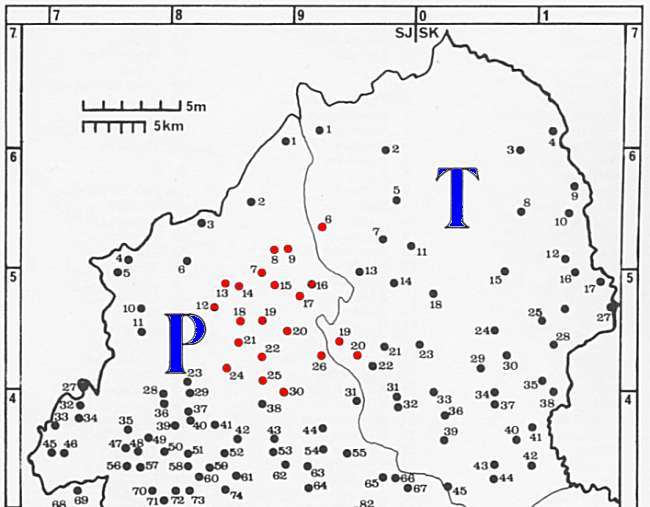
Pirehill and Totmonslow Hundred
The area of Stoke-on-Trent falls almost exclusively into the north part of
![]() on
Pirehill and Totmonslow Hundred
on
Pirehill and Totmonslow Hundred

|
|
Click on the map numbers for the Domesday
Record
|
|
| questions/comments/contributions?: email: Steve Birks |