| Stoke-on-Trent Districts: Bank Top |
![]() more aerial photos around the city
more aerial photos around the city
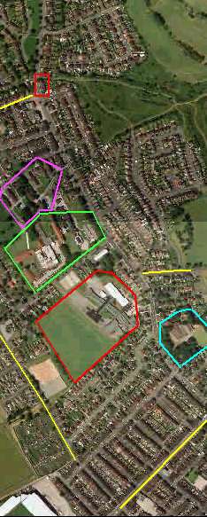
aerial photo of the features of High Lane and Bank Top
|
|
The red box is
the small row of terraced houses on the corner of Bank Top Avenue. The
row is called "Riley Terrace"
The yellow line is Greenbank Road |
| The purple area is the old Stanfield Sanatorium and the green area is the new Haywood hospital complex. | |
| Short
yellow road to the right was an unnamed track on the 1890 map which
became Acreswood Road.
The light blue area is the location of "Bank House" The red area is Stanfields School grounds - in 1925 this was a cricket ground behind a Methodist church. |
|
| The yellow line
in bottom right corner is Hamil Road - the yellow line on the
left is Dolly Lane - both these appeared on the 1890 OS map.
In the bottom left corner is the corner of Port Vale football stadium. |
![]() more aerial photos around the city
more aerial photos around the city