|
Cobridge:
"Cobridge is now a
populous district, extending from the suburbs of Shelton to Burslem,
and mostly in the latter parish, and partly in Shelton"
From
History, Gazetteer and Directory of Staffordshire, William
White, Sheffield, 1851
Cobridge in the 1700's:
Ward records (1843) "in documents dated more
than a century since the place is called Cobridge Gate, and then it
consisted of a few tenements and small potteries erected near a gate opening
into a lane leading from the Grange of Ruston to the Abby of Hulton..."
On the 1775 Yates map there is a few buildings
in the location known as 'Cow Bridge' situated near the bottom of what is
now Sneyd Street (and located on the map as Snead Green) and the present day
Century Street.
Century Street and part of York Street was the way into Hanley from Burslem
- the direct route of Waterloo Road was not completed until 1817.
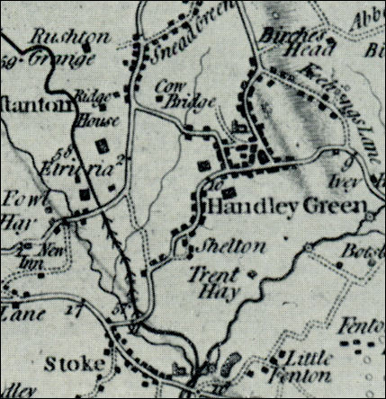
Extract from William Yates
1775 Map of Staffordshire
Showing "Cow Bridge" between "Handley Green" and "Snead Green"
- click map for larger
area of map -

|