![]()
![]()
- the parish of St. Simon and St. Jude

|
|
|
| A photo walk across Stoke Fields to Winton's Wood, Stoke-on-Trent - the parish of St. Simon and St. Jude |
|
St. Jude's Church and Town
![]()
![]()
![]()
next: the 'incomers'
previous: railways and chartists
|
By 1860 Stoke Road was becoming quite built up with new houses for professional men and commercial premises, conveniently between Hanley and Stoke, and nearer to the railway than either. The railway now had over 113 miles of track with connections to all the major cities, and a local network serving the whole district. The old Toll Gate cottage had ceased to collect tolls, as its function had been taken over by the new Municipal Borough of Hanley, previously part of the Borough of Stoke-upon-Trent. Down towards the railway bridge a speculative builder had laid out Queen Anne Street, which with the adjacent Panton Villa was convenient for railway workers. Over in Stoke Fields, Victoria Place near Shelton Church had been extended over the farm land, across Winton's Wood Glebe land to Station Road, and was now called Victoria Road. Similarly Stoke Road had been linked to Leek Road by the new Cauldon Road. At the other end of Station Road, a triangular area of streets had been laid out near Winton Terrace, with modest dwellings for artisans and workingmen. Inglis, Lawrence, Havelock, Clyde, Wilson and Mayo Streets were centred on the new Roebuck Public House, a favourite haunt with railwaymen and carters. The Leek Road level crossing had long been superseded by a new bridge under the railway into Glebe Street. This had been made necessary by the increasing conflict between rail and road traffic, even before the appearance of motor vehicles. The old level crossing route had been diverted down towards the Trent at the Seven Arches Viaduct to by-pass Stoke. Leek Road now had its row of terraced houses and the Terrace Public House, looking east beyond the river, over Squire Broade's. The first house on Leek Road was named aptly enough "Manor View", and still is.
Building
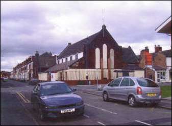
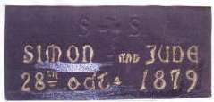
development: The land immediately adjacent to Stoke Road was the first to be developed, at Aynsley Road, Haywood, Newlands, Northcote and Elgin Streets on Shelton Hall Estate land, and Cauldon Road, Beresford, Seaford and Ashford Streets on Stoke Parish Glebe Land. Meanwhile Victoria Road was sporting a row of commercial premises towards the Station Road end, and a cricket ground for railwaymen was established on land behind the North Stafford Hotel. In 1879 the Rector of Stoke built a Mission Church at the corner of Beresford Street and Victoria Road, anticipating the spiritual needs of the growing population, although there had been a Mission Chapel at St Anthony's Row, Newlands Street for some years earlier. The Rector of Stoke, John Herbert Crump appointed Rev. Edmund Spink as Curate of the new Mission Church of St Simon and St Jude in the centre of the new suburb.
For the next fifteen years the whole area must have resembled one endless building site. The noted architect George B. Ford, designer of schools, churches and hospitals was retained to oversee the "ford" streets. Ford, Guildford and Watford were added to the extensions of Beresford, Seaford and Ashford Streets, which all included a reference to his name for posterity. On the other side of the fields behind Leek Road, Boughey Terrace was built, its name reflecting the owners of the land - the Fenton-Boughey family, and the wall plaque shows the date 1882 for provenance. Ashford Street connected with Boughey Road, as it became, with the side streets of Carlton, Thornton, Spencer, Conway and Darnley Streets completing the pattern. The south side of Cauldon Road was similarly developed in part. The rows of terraced houses were interspersed with shop premises and gaps reserved for future specialist development. The pavements would have been surfaced with blue bricks, and the carriageways channelled and sewered, but not made-up; they would have been termed "Private Streets", not being the responsibility of the Local Authority. In later years, Acts would be passed to enforce the frontagers to pay for their making-up, after which the streets would be taken over by the Authority. Towards the end of the century, when the introduction of motor vehicles demanded even better roads, the top layer of water-bound macadam gave way to a mixture of coal gas tar and gravel or even the natural asphalt which was being discovered throughout Europe. The asphalt lake in Trinidad was also becoming a prime source of supply.
Public services:
On 11th of May 1895, Queen Victoria in Council at Windsor decreed "... a separate district for spiritual purposes in that particular part of Stoke-on-Trent..." Here the Order in Council went on to define precisely to the last linear foot, the bounds of the new parish of St Simon and St Jude,
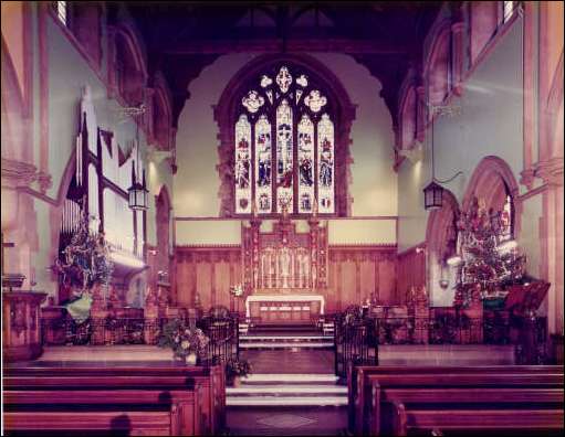
here the description resorts to roads, railways, natural and man-made features with precise distances in chains and feet. The new church was to be built on land set aside from the housing development in Seaford Street, Cauldon Road and Beresford Street, and a further plot was reserved on adjacent land in Seaford Street, for a new parsonage at a cost of £135. The Shelton architects, Scrivenors were retained to design and build the new church with 800 seats, at a cost of £10,000.
St Jude's was consecrated in 1901, the
living being in the gift of the Rector of Stoke. The capable and loyal
curate Edmund Spink was appointed to the living and in 1902 became
rector in his own right.
|
![]()
John Alcock - (c) Copyright 2006