|
“The
canal was cut along a four-mile level straight through the heart of
Stoke,” says historian Steve Birks. “Its starting point is marked by a
sign underneath Glebe Street Bridge. The canal is long gone and it’s
almost impossible to trace it. Mind you, just thirty-years ago there was
still a hundred-yard navigable stretch that was used as moorings for Stoke
Boating Club. That was the last bit of it to be wiped-out by the A500.”
The
Newcastle Canal was one of those ventures that seemed to be a good idea
at the time. It opened in 1800 and was part of an impressive plan to
link Newcastle to the Grand Trunk network. It didn’t turn out that way
as Andy Perkin, secretary of the Potteries Heritage Society explains.
“The
local iron and coal master Sir Nigel Gresley had already opened a canal
from his mines at Apedale to carry coal to Newcastle. Cleverly he’d
obtained legislative approval to control the price of coal in the district
for forty-two years; in other words he held a monopoly. The main
money-spinner for the Stoke to Newcastle canal naturally would have been
coal-carriage. Gresley’s clause effectively ruled out competition and the
originally scheme that proposed to link the two canals by an incline plane
through Stubbs Walk never materialised and people just lost interest in
the whole venture.”
Manufacturers at the Stoke end, men like Spode, Minton and Wolfe, had no
real need for the Newcastle Branch other than the bit that led to the
Grand Trunk connection.
“There
was little use for the main stretch of waterway and so it was part-closed
in 1921,” Steve continues. “By 1935 it had been abandoned altogether and
so it was filled-in and forgotten as a disastrous failure.”
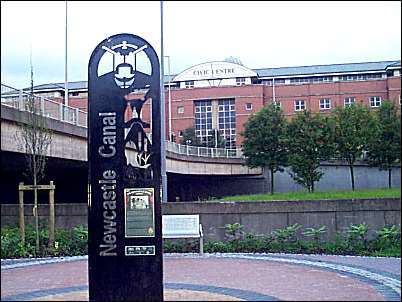
This photo taken from the
footpath on the Trent and Mersey Canal
The sign pinpoints the
junction of the Newcastle Canal where it ran into the Trent & Mersey Canal
near Glebe Street (just opposite the railway station).
Until the early 1970's there was a 100 yard stretch of navigable Newcastle
Canal here which was used as moorings for Stoke Boat Club, this stretch
was wiped out when the huge A500 by-pass was built.
On the far side of the
Civic Centre is the Spode Factory.
|
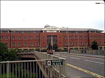
The Civic Centre at the
top of Glebe Street
the canal ran where the civic
centre is now built
photo: July 2000
Never mind, Steve and I decide we owe it to history to try and trace
its route anyway; to see what remains of any evidence of its existence.
The first port of call is the Civic Centre where I meet up with Town Hall
porter David Bowes, a civic stalwart who has looked after our town halls
for the past 30 years.
“One of
my tasks is to go into to the cellars of the old Stoke Town to make sure
the back-up batteries are charging and to check the water pumps are
working. We’ve had a lot of problems with flooding over the years with
water coming in when the Fowlea Brook overflows.” explains David.
Hidden
beneath the tumult of road and railway is the oldest part of Stoke Town
Hall. Down here, in the 1834 vaulted chambers, regiments of heavy-duty
batteries stand-by in case of power failure. Here among the chill cobwebby
corners, miles of pipes and cables coil beneath the engine rooms of civic
administration. Stone compartments concede space to other rambling rooms
echoing with dripping water. David points to an uncovered hole in the
ground.
“That’s
the overflow from the Fowley Brook,” he says casually. “The hole is an
inspection gauge where, as soon as the water rises above a certain
level, a pump kicks in and directs the flow back out so it causes no
damage.”
These
problems were identified in the 1980’s when the rise of the Fowlea Brook
caused serious damage to irreplaceable files and documents.
“Hopefully that won’t happen again,” says David, “But we have to keep a
continuous check to make sure the pump is working correctly.”
Most of
our important historic documents are stored these days in Hanley archives
so a repetition of flooding can’t do much damage. But the proximity of
Fowlea Brook will, no doubt, always cause speculation.
"Fowlea by name and foul by nature"
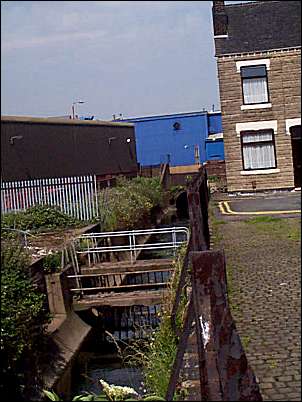
The Fowlea brook as it
runs at the bottom of Leason Street in Stoke.
On the left the brown building is
part of the Spode factory and in the middle the blue building is
anindustrial electrical factory on Elenora Street.
The Fowlea Brook runs through a culvert under Elenora Street
Above ground Steve points out the fast-flowing Fowlea Brook as it
passes below and between the Civic Centre and the Town Hall under Aqueduct
and Brook Streets.
“Our
canal once passed behind the Town Hall over the brook and by the rear of
Spode Works. From here it travelled under Church Street and under
Campbell Place in a tunnel. It appeared briefly at the side of London
Road opposite Hill Street picking up a spur from the Wolfe Street
potteries. It finally emerged from two tunnels by Fleming Road. And then
off it went under what is now Sainsbury’s until it crossed Corporation
Street. This is our first evidence that the canal existed for you can
still see two parapet columns that have been left as you enter a
children’s play area.”
The open canal rejoined London Road near to All Saints Road where, just a
short distance away, a memorial erected to mark the bravery of Timothy
Trow now stands. But that’s a story for next week.