Stoke-on-Trent - photo of the week


contents: 2010 photos


click for
previous
photos

Advert of the Week
Potworks of the Week


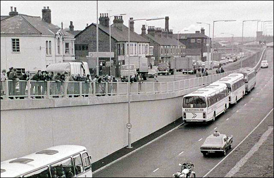
A500 - Potteries D Road


the Stoke-on-Trent 'D-Road' as it enters the city from the north
the A527 to the left towards Tunstall and to the right is Porthill Bank
immediately on the left is Longbridge Hayes Road.

Photo: John Laing and Sons Ltd, main contractors for the A500
Stoke-on-Trent county Borough Council 1910-1974


"As we move into the middle of the second half of the 20th century, Stoke-on-Trent is ideally situated and admirably served by a comprehensive network of road and rail services.

The city stands on the main Manchester to London railway line with speedy and efficient services to the north and south. A few miles to the west passes the M6 motorway, south to Birmingham, London and Bristol, north into Scotland and with motorway links into Yorkshire and, shortly, into Liverpool. The picture is completed by the proximity of Manchester Airport to the north and Birmingham airport to the south, both less than an hour's drive away, mostly by motorway.

Within the city, a link from interchange 15 on the M6 at Hanchurch runs to a junction with the A34 trunk road at Hanford. Another link from interchange 16 on the M6 at Barthomley runs to the city boundary at Etruria just over a mile from the city centre in Hanley. Work is expected to start shortly on a scheme to connect these two links through the city, passing close to the eastern side of Stoke.

The complete length of road between Barthomley and Hanchurch is known as the Potteries 'D' road which through the urban areas is being developed to urban motorway standards. Interchanges with Etruria Road (A53), Stoke Road and Liverpool Road (A5006), City Road (A5007) and Stone Road (A34) within the city will provide excellent access to the road from the central and southern areas of the city, while the northern areas will be served by junctions at Porthill Road (A527) just outside the city boundary and at Talke (A34) about a mile from the boundary.

A further major development, fully planned by the council but stopped in its tracks, so to speak by national financial considerations, is the Derby Way. This, again, will be a road of urban motorway standards and will extend from an intersection with the 'D' Road near to the Stoke City Football ground to a point where the A50 trunk road crosses the city boundary at Catchems Corner where it will connect directly with the Blythe Bridge by-pass now under construction.

Interchanges with the major primary and distributor roads will further improve accessibility to the M6 motorway while offering considerable relief to the existing roads within the Longton, Fenton and Trentham areas of the city."

From: Stoke-on-Trent county Borough Council 1910-1974


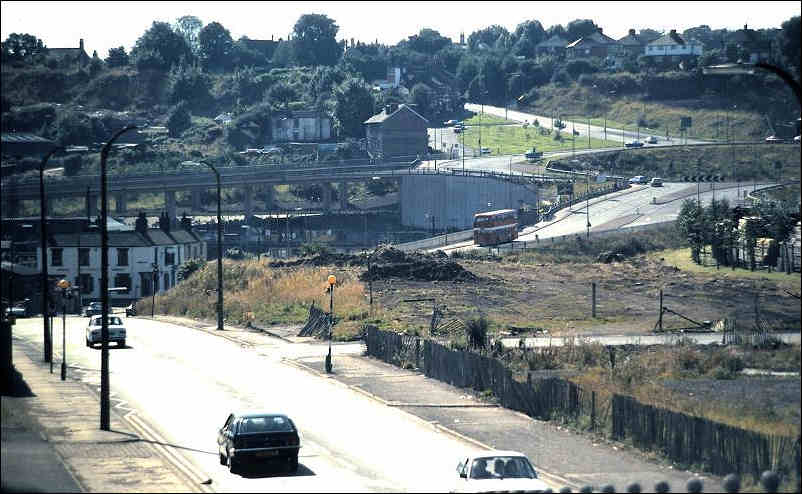
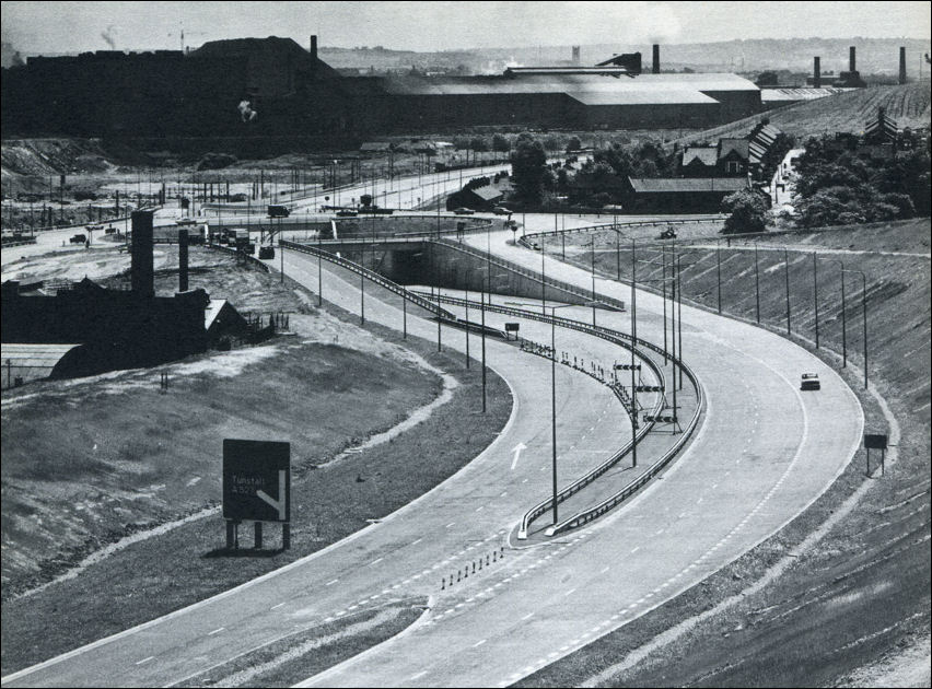
the A500 'D-Road' at Etruria
the section from J15 of the M6 motorway to this point in Etruria was completed from 1974-1977
the D-Road running left to right across the centre of the picture
in the foreground is Lord Street, Etruria and top right is Basford Bank (the A53)

photo: Ken Cubley


The A500 'D' road
 

By the 1960s, traffic congestion was a major problem in Stoke-on-Trent, and journeys across the area sometimes took hours. There was no connection from the newly constructed M6 to the city. Businesses in the area wanted an easier route to get their goods out of the area.

1962 - M6 J16 to the A34 at Talke
The A500 was initially built from the M6 at junction 16 to the A34 road at Talke as part of the motorway construction, opening in 1962. At the southern end, a dual carriageway was constructed from junction 15 of the M6 to the A34 near Trentham, given the number A5006, and opened at the same time. The northern section of the road was then subsequently extended from Talke to the A53 road.

1974-1977  - A34 at Hanford to the A53 at Etruria
The final section from the A34 in the south to the A53 junction was built between 1974 and 1977. The two middle junctions were to be grade separated, but due to financial constraints they were built as roundabouts.

Construction involved the destruction of streets and businesses within Stoke's town centre, as well as the excavation of a mass grave of the victims of a 17th-century cholera epidemic. This final section was named Queensway, and on its completion the whole route became the A500.

official opening of the Etruria to Hanford section of the A500


Saracen's Head public house in Glebe Street, Stoke
demolished to make way for the A500

photos: Ken Cubley
 

1980's - Hanford flyover
The route remained unchanged until the 1980s when the Hanford Roundabout junction had a flyover built, as this was a major bottleneck for both the A500 and A34. The 1977 section east of this junction had been built with provision for the bridge, but the section built as the A5006 required realignment for the new interchange.

1997 - the A50 extended to meet the A500
In 1993 a proposal was made to add the missing flyover and underpass close to Stoke-on-Trent railway station, after an alternative plan had been rejected because of its cost. A full review of the national roads programme resulted in the suspension of that scheme however. In 1997 the A50 was rerouted through Stoke-on-Trent to meet the A500 at Sideway, where a new roundabout was constructed.

2004 - 2006 - the underpasses through Stoke
Traffic continued to rise to the point where major congestion was experienced on the central section. Work began on 16 February 2004 on the A500 Pathfinder Project to replace the final two roundabouts in Stoke with underpasses. The Highways Agency defined the pathfinder project as involving "a new form of contract and co-operative working methods to deliver a better value project, faster." The project involved alterations to the path of the Trent and Mersey Canal and River Trent, along with new provisions for pedestrians.

traffic congestion during the A500 Pathfinder Project
Feb 2005

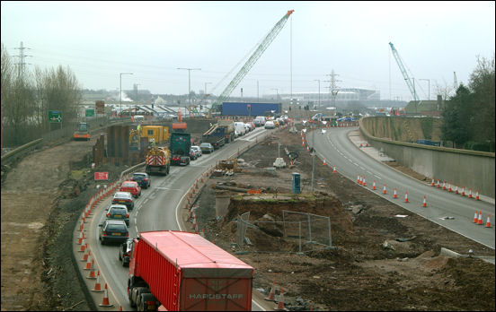
The work was carried out by Edmund Nuttall Limited and was planned to be completed in spring 2006. Following a number of delays for which it was rumoured the construction company was being fined up to £100,000 a day for not keeping to schedule, the road opened on Tuesday 26 September 2006, with the southbound traffic in the morning and northbound traffic in the afternoon. Several months of additional work was needed to finalise traffic light operations, gardens, and other miscellaneous tasks.

from Wikipedia, the free encyclopedia


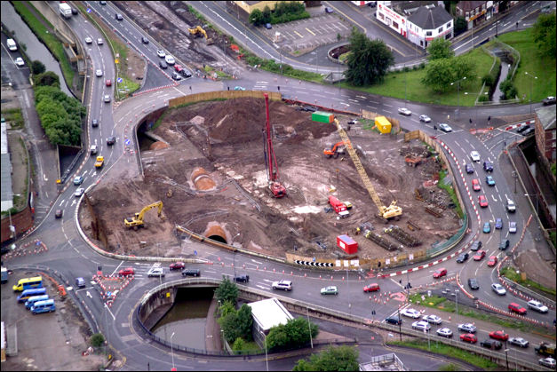
the roundabout at the bottom of Stoke Old Road
in the centre of the roundabout excavation for the underpass is taking place
to the left the Trent & Mersey canal is being re-routed, to the right is the Fowlea Brook
 

Feb 2005 - work on the two underpasses on the A500 at Stoke
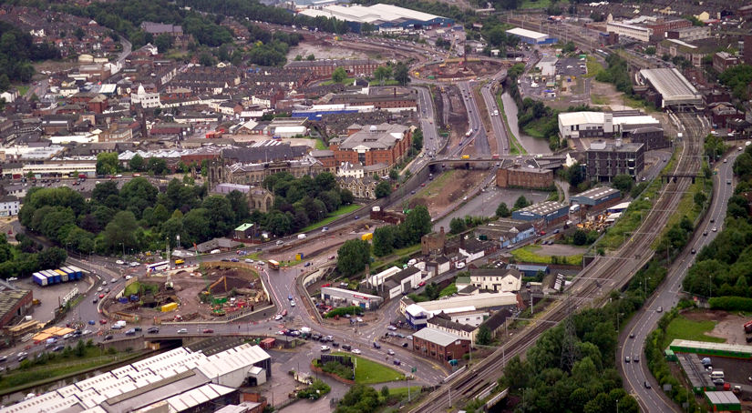
buildings that can be identified on this photograph include......
Minton & Hollins works, Staffordshire University, Federation House, Stoke Railway Station,
Stoke Civic Centre, Spode Pottery Works, Stoke Town Hall,
Stoke Minster (St. Peter's), Brook Street houses, Dolby Bottle Kiln.


contents: 2010 photos