Hulton Abbey to Ruston
Grange
Ruston Grange
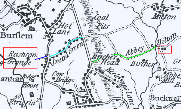
Yates 1775 map showing
Abbey Hilton and Ruston Grange
At the bottom of Sneyd Street was a track
which is now Grange Street (dark blue line) leading to Ruston Grange
Grange Street
In
the early 13th century the estate known as Rushton comprising 420 acres
was the property of Henry de Audley.
In
1223 he included the estate among the endowments of the Cistercian abbey
at Hulton. The monks established a grange or sheep farm on the land which
they held until the dissolution of the monasteries by Henry VIII in 1538.
The Crown granted the estate to James Leveson of Wolverhampton in 1539 who
sold it in the following year to Richard Biddulph of Biddulph for £130
7s.
The Biddulph family were Roman Catholics and the Parliamentary Committee
for the County of Stafford sequestered the estate during the civil war.
|
Their order book
for 1643-4 (SHC 1956) recorded:
“It is ordered
that Mr Gabriel Keeling of Biddle shall hold from the Annunciation
next for and during one whole yeare one Messuage or Tenement in
Burslam called and knowne by the name of Rushton grange and the
Colemines there beihg the land of Francis Biddulph Esq. a delinquent
now sequestered with liberty to get and burne limestone to be spent
upon the lands and 40 Tunne of limestone to dispose otherways as he
shall please yielding and paying to our Treasurer the summe of £70
at foure payments viz. our lady day, Midsomer, Michaelmas, and
Christmas:
And likewise
paying and discharging the weekly pay during the said due for the
premises, and allowing to the widow Bagnold house room in the said
grange and keeping of as many cowes in the said grounds as she had
last yeare, she not misdemeaning her selfe against the said Gabriel
Keeling.”
|
The Bagnalls:
The
Bagnalls another Roman Catholic family were tenants of Francis Biddulph.
Part
of the farmhouse was used as a place of worship by the Roman Catholics in
the area. Their tenant, John Bagnall was forced to flee the house during
the disturbances associated with the flight of James II in 1688 and the
property was ransacked by a mob from Burslem and the neighbourhood.
John Bagnall described
himself as a potter in his will made in the same year and Josiah
Wedwood’s list of master potters in Burslem records that the Bagnall
family “of Grange" were making butter pots with a weekly production to
the value of £2 in 1710-15.
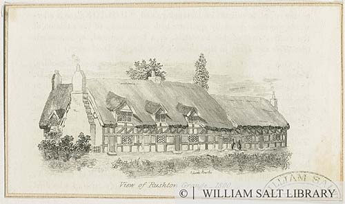
'View of Rushton Grange -
1800'
showing a row of four timbered, thatched
cottages. Artist: Edward Brooke.
© William Salt Library (Staffordshire Past
Tracks)
In the
second half of the 17th and the 18th century the Biddulph family sold the
land on the east side of Rushton Grange and by the early 1840s the estate
had been reduced to 220 acres.
Most of the land was let to
William Gething who was recorded in the 1851 census returns as the
occupier of 103 acres on which he employed 4 agricultural labourers. By
then the Grange farm had been divided into two with the other part
occupied by William a farm bailiff, his wife and an agricultural labourer.
The expansion of the pottery
factories at Cobridge and the construction of new houses after the
building of Waterloo Road brought problems as well as opportunities for
the occupier of the Grange Farm.
One result was that more and more people used the footpaths which crossed
the estate between Cobridge Burslem and Wolstanton.
|
The Staffordshire Advertiser
reported on 14 August 1847:
“Caution to
Trespassers in WheatfieIds: William Meadows was charged with
stealing and damaging a quantity of growing wheat, value 4 shillings
at the Grange Farm, near Burslem, on Sunday afternoon. There is a
footpath along the field, and the prisoner was observed to leave the
path, and go about 4 yards into the wheat, which he plucked and
trampled down. After hearing the evidence of Mr Gething, the
occupant of the farm, and a bailiff, who fully proved the damage,
the Magistrates considered the charge fully sustained, and ordered
the payment of 4 shillings as the amount of damages, with a fine of
10 shillings and 9 shillings and 6 pence expenses, or to be
imprisoned by default.” |
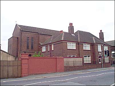
St Peters Church
the Presbyters home
The red wall is part of the original Soho potworks of John and
George Alcock
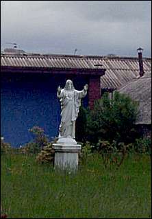
Statue of Christ in
the rear grounds of St. Peters
photo taken from Grange Street
The
Warburton and the
Blackwell families were the principal supporters of the Roman
Catholic community in the area. In 1780 they helped to finance the
construction of a small Catholic chapel at the end of what is now Grange
Street then the lane leading to
Rushton Grange Farm.
John
Ward in his book The Borough of Stoke-upon-Trent (1843) recorded
that:
“the walls of
this chapel had just been raised above the ground when the
Protestant riots in London, with which the name of Lord George
Gordon is associated, took place, and the alarmed Catholics of
Cobridge suspended their building for several months... The chapel
was enlarged in 1816; it is calculated to accommodate about 150
persons, is an unassuming building, almost concealed by the
Priest’s dwelling-house, and an adjoining school-house erected in
1822
|
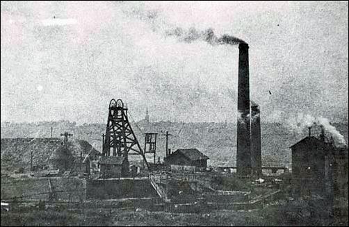
Grange colliery (c.1860-1920)
This pit was sunk around 1860 at Rushton Grange,
near Cobridge, for coal and ironstone for Robert Heath’s Ironworks at
Black Bull, Biddulph. Severe flooding took place in 1917, and this also
affected the Racecourse colliery. Later, a large beam pumping engine,
called the ‘King Edward Pump’ was installed to drain the Grange and
Racecourse colliery.
© Staffordshire Past Tracks
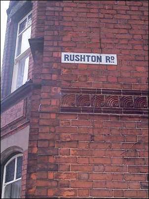
Ruston Road - Cobridge
Rushton Road was part of
the development of Henry Meakin's estate, the land was offered for sale at
the
Queen's Hotel in Cobridge on 4th March 1879.
On the original Auction
plan this road was named 'Station Road' because it led to Cobridge Railway
Station, however by the time of the 1898 &
1924 OS map it was called 'Rushton Road'.
It was named Ruston Road after the
Rushton Grange Estate.
 
previous: Forest
Park Link & Cobridge School |