The Geography
of the Potteries (Stoke-on-Trent)
![]()
![]()
![]()
![]()
![]()
| Index - Subsidence in Stoke-on-Trent |
Subsidence of Wedgwood's Etruria factory
next: 1877 OS map of the works and canal
In 1769 Wedgwood opened his new works on a site in Etruria, which he purchased because he knew that the Trent and Mersey canal would run past the site. The canal was opened in 1777.
From about 1900 onwards the factory sank because of the presence of extensive mining operations.We can prove that the site of the factory sank about 2.5metres (8 feet) by the use of pictures and maps.
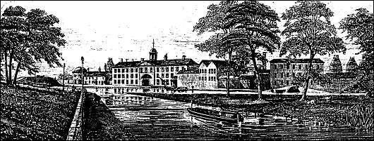
c1860 view of Wedgwood's Etruria Works
on Wedgwood's Works
In the front of the works is the Trent and Mersey canal. There was a
short branch canal which ran off the main canal and into the works
- a bridge over the junction of this branch canal can be seen
to the right of the picture.
The canal and works were on the same level
A 1877 OS map of the works clearly shows the branch canal running into the works - this demonstrates that the works and canal were on the same level.
Two pictures (water colour picture and 1898 photo) which show the factory canal and tow path on the same level.
Two photos (one late 1930's and one 2000) which clearly show that the factory site has suffered from severe subsidence.
next: 1877 OS map of the works and canal
![]()
![]()
questions/comments/contributions? email: Steve Birks
![]()
![]()
![]()