|
Bradwell Hall and
the Sneyd family:
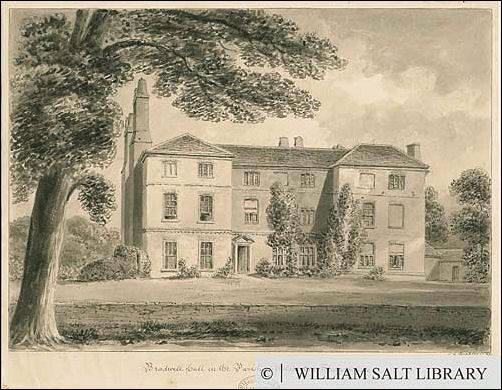
Bradwell Hall
1841
'Bradwell Hall in the Parish of Wolstanton, Staffordshire.'
Showing a three storey late Georgian house of brick, in a garden,
with a sunken wall in front.
J. C. Buckler.
© William Salt Library - Staffordshire Past Tracks
"The Sneyd family can
be traced back to the beginning of the 14th century when they owned
land at Tunstall and Chatterley. By the beginning of the 15th
century they were resident at Bradwell Hall, which was the principal
residence of the family for the next 180 years.
The economic and social rise of this yeoman family began with the
removal of William Sneyd to Chester in 1461. When his grandson,
William Sneyd, returned to North Staffordshire almost a hundred
years later the family had acquired substantial wealth by trade, the
holding of lucrative offices and by advantageous marriages.
William Sneyd made
extensive purchases of land in Staffordshire and elsewhere including
the manor of Keele in 1544; was made Knight of the Bath in 1547; was
sheriff of Staffordshire in 1549 and 1558; was granted the patronage
of St. Margaret's church, Wolstanton, in 1567 where he was buried in
1571.
His successor Ralph
Sneyd built a new house at Keele which became the principle family
residence in 1581. However, members of the Sneyd family continued to
live at Bradwell Hall for a substantial part of the next 250 years."
Andrew Dobraszczyc
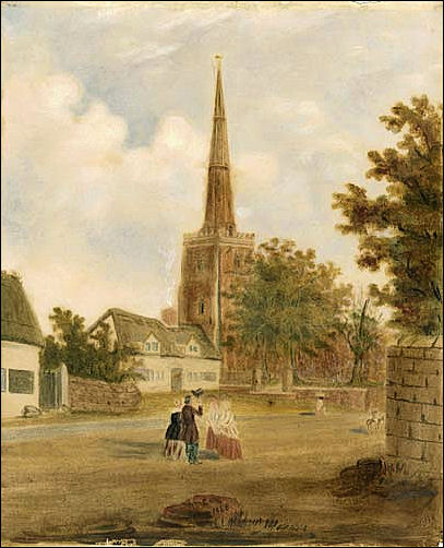
A watercolour by
R.M. Colley, looking towards St. Margaret's Church, Wolstanton.
St. Margaret's Church is depicted here in its pre 1858 state.
Between 1858 and 1860 the church was altered by Gilbert Scott
in the style of the Gothic revival.
© Borough
Museum and Art Gallery, Newcastle under Lyme, Staffordshire Past
Tracks

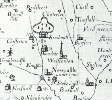
Bradwell Hall and
deer park - Plot's 1686 map
The extract above from
a 1686 map of Staffordshire shows the location of Bradwell Hall
north west of Chesterton. It also shows that the family had acquired
another symbol of social status - a deer park - located north of the
house.
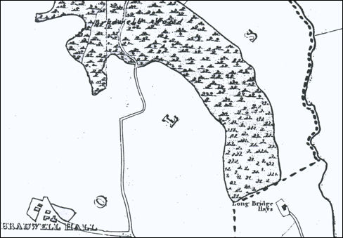
1832 Hargeaves map
of Bradwell
-click for larger map-
Bradwell Hall was built on the top of a small hill at a height of
just over 600 feet above sea level which gave the occupiers
extensive views over the surrounding landscape.
As
seen in the 1832 map above - one of the most important features in
that landscape was Bradwell Wood which occupied an area of about a
hundred acres north east of the Hall.
All the early maps show that the main access to the house was not
from the main road on the west (the present A34) which ran through
Chesterton but from a lane on the east which ran north from the
village of Wolstanton through Bradwell Wood to Chatterley Hall.
The
lane clearly shown on the map above followed the route of the
current streets -Bradwell Lane, Arnold Grove and Riceyman Road. The
dotted line has been added to indicate the boundary of the the Sneyd
estate which on the east side generally followed the line of the
Fowlea Brook.
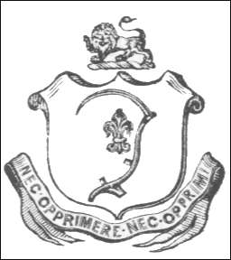
Sneyd Family Arms
The scythe is representative of the
original woodland nature of the district.
The Fleur-de-lys was granted for deeds done in the French wars under
the Plantagenet Kings.
Amongst others,
the Sneyd family owned the large tract of land, in the parish of
Burslem which bears the name of Sneyd.
Bradwell, in the Manor of Tunstall was formally the chief seat of
the Sneyds. Hence the scythe from the Sneyd farms is found in both
the
Tunstall
and
Burslem
arms.
In 1310 Henry de
Sneyde married Margaret the daughter and heiress of Nicholas de
Tunstall.
Some of the immediate
descendants were called "De Tunstall" otherwise Sneyd. But
the alias was retained for only three or four generations.
|
Bradwell
Nursing Home: In the early 1930's Newcastle Borough
Council (which had absorbed part of the area of Wolstanton
Urban District Council) began to layout the streets below
Bradwell Hall.
Housing development was interrupted by the outbreak of the
Second World War in 1939 and did not resume again until the
late 1940s. Within the space of twenty years the whole of the
area south of the Hall had been built up with semi-detached
houses by Newcastle Borough Council and by private developers.
Meanwhile, after the death of Ralph Sneyd (1863-1949) his
executors broke up the Keele Hall Estate and Bradwell Hall was
sold to the Twigg family in 1951.
There was a fire at the Hall in 1985 and the house was
subsequently refurbished by Twigg family and converted into
the Bradwell Nursing Home. |
|