| Stoke-on-Trent Districts: Sytch |
Sytch, Burslem, Stoke-on-Trent, Staffordshire.
|
|
location and development of the name (this page) |
|
|
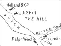
Maps of Sytch |
|
|
Sytch : The Vanished Landscape |
![]()
|
Sytch, Burslem, Stoke-on-Trent, Staffordshire. Sytch - a small area north west of Burslem town centre. [sometimes spelt "sitch"] The Sytch starts at Hill Top and encompasses the area around Westport Road as it runs down, over Scotia Brook, to Brownhills Road at the bottom.
"The Sytch was the dark heart
of the Potteries, an immense stretch of ground composed in almost equal
parts of bare clay earth, black water, mud, industrial detritus both active
and abandoned, and fumigerous furnaces, belching forth fire, ashes and
smoke."
Development of the name:
Potters on The Sytch:
|
![]()
more on Sytch
questions / comments / contributions? email: Steve Birks
8 January 2006