|
Hulton Abbey to Ruston
Grange This
article examines Hulton Abbey, the trackway along Sneyd Street and the
monks farmland at Ruston Grange.
The site of Hulton Abbey is located
just off the junction of the A5009 Leek Road and Woodhead.
the Abbey site and
Charles Lynam
The Abbey was founded by
Henry De Audley in 1219 and consecrated in 1223. Following the dissolution
in 1538 the site eventually was lost until 1884; it was located during a
chance excavation, later being investigated and published by Charles Lynam
who was a local architect.

Among Lynam's archaeological achievements
were the elucidation of the ground
plans of Croxden Abbey, near
Uttoxeter, and Hulton Abbey, Stoke. His work on the
later was used 50
years later to prevent the erection of a housing estate over the
hidden foundations of
the abbey.
He also undertook excavation work on the bath-house at the Roman site of
Wall, near Lichfield.
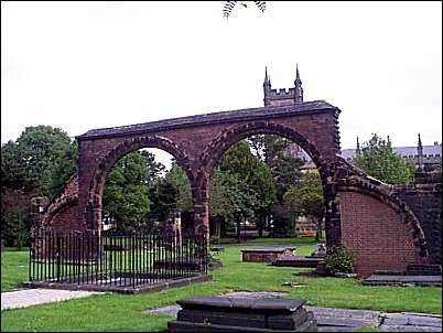
arches of early Stoke
Church - erected by Charles Lynam
The old parish church of
Stoke upon Trent had been demolished in 1830 and some of its stone used to
form the bed of a watercourse
serving Boothen Mill. Lynam
discovered these in 1881 and used them to reconstruct
two arches and other
features of the old church, set up on the site of the old church.
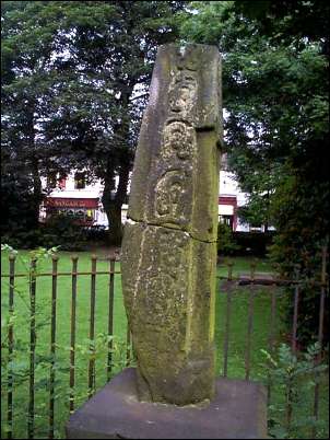
The fragment of the Saxon
preaching cross
in the grounds of St. Peters
The fragments from the
medieval (pre-Norman (1066) preaching cross were identified by the local
architect Lynam and erected by him in mid 19th century in the grounds of
St. Peter Ad Vincula
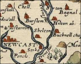
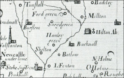
a section of a 1577 map of
North Staffordshire showing 'Hilton abbey'
Plot's map of North
Staffordshire c.1670
the monks lands and the track to
Ruston Grange
Abbey Hulton takes its name from the
former Hulton Abbey, which was located about half a mile from Milton, on
the east side of the road from Stoke to Leek, next to Carmountside Primary
School. In the Domesday Book, Hulton is recorded as ‘Heltone’ meaning
‘hill town’
The monks were engaged in sheep-farming
by the mid 13th century. Granges were established at Rushton and
Hulton soon after the foundation of the abbey, and there is mention of the
abbey's sheepfold at Normacot in 1242.
Sneyd Street was part of an ancient
trackway between Hulton Abbey and the monk's farm at Rushton Grange (now
near Cobridge).
early connections between
Hulton and Ruston
although the Abbey was
not founded until 1219 there was a connection between Hulton (later Abbey
Hulton) and Ruston (later Ruston Grange) as recorded in the Domesday Book of
1087.
'Land
of Robert of Stafford.....'
RUSHTON
[RISCTONE]
HULTON [HELTONE] |
|
Robert
also holds the third part of 1 hide in HULTON and RUSHTON. Wulfgeat holds from him. He held it himself before 1066. Land for 3 ploughs.
3 villagers and 3 smallholders with 1 plough.
Woodland 1 league long and ½ wide.
Value 10s. |

next: map and site
guide to the Abbey
|