![]()
Longport: The 'Kingdom' of
Davenport![]()
![]() (1760's - mid 19th C))
(1760's - mid 19th C))
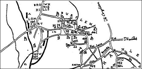
Allbut's 1802 map showing location of potworks in Longport
The map above, an extract from a map of the Staffordshire Potteries published by J Allbut, Hanley, shows the location of the 4 Longport pottery factories in 1802.
Longport Pottery (No 19), built by John Brindley, was occupied by John Davenport;
Top Bridge Pottery (No 20) by Henshall, Williamson & Co;
Bottom Bridge Pottery (No 21) by Williamson & Henshall;
No 22 by Shirley, Lindop & Co. Factory No 23, at Dale Hall, was in the ownership of John & George Rogers.
Walter Daniel built Newport Pottery (No 24) further down the canal in 1795.
Two wharfs are also marked on the map:
“A”, William Kenwright’s wharf below Brownhills, (agent Thomas Appleby)
“B”, the Trent and Mersey Canal Wharf (agent William Banks).
The line of the Burslem Branch Canal is also shown on the map (marked as “C”) though this was not completed until 1805.
Hugh
Henshall who completed the construction of the canal after the death of James
Brindley (![]() )
in 1772 operated the main wharf at Longport. The wharf is shown in more detail
on the 1851 map of the Top Bridge Pottery where the site has
been identified by a dotted line.
)
in 1772 operated the main wharf at Longport. The wharf is shown in more detail
on the 1851 map of the Top Bridge Pottery where the site has
been identified by a dotted line.
The wharf keepers house was demolished when the Price & Kensington factory was extended but the little canal office and the warehouse are still standing.
On
the opposite side of the canal Henshall built a new public house in the late
1770s, the Packhorse Inn, to provide accommodation for
boatmen and carters and their horses. When it was offered for sale in 1871 it
was described as containing “extensive cellaring, bar, bar parlour communal
room, tap-room, kitchen, scullery, large billiard-room and club room to seat 150
persons, and the outbuildings comprise large brew-house, malthouse, stabling for
11 horses, coach-house, piggeries, and large skittle alley.” It can be found
on the 1851 OS map
of the Bottom Bridge Pottery.
![]()
questions/comments/contributions? email: Steve Birks