Search for the Old Roads of Stoke-on-Trent


The monks of Hulton Abbey


click the "contents" button to get back to the main index & map
next: the monks and Sneyd Green
previous:
Dalehall, Burslem


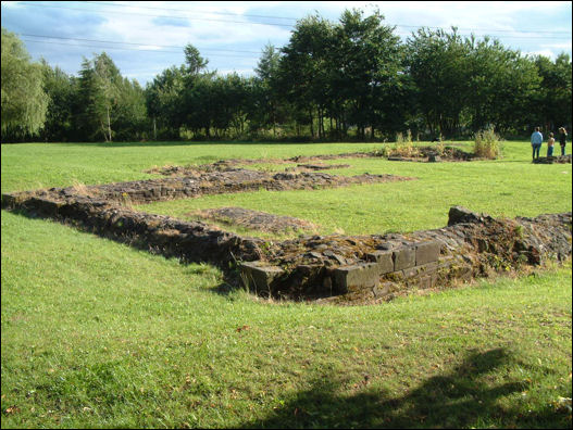
Historian Fred Hughes writes....   

Charles Lynam was certainly a larger than life Potteries character. He took over his father’s architectural and surveying business in Glebe Street in 1850 and soon had total monopoly of the building commissions awarded by local public bodies. How he achieved this is a matter of which side you take, he was after all an alderman and a councillor, a position some rivals suspected he used to his advantage. He was at the same time surveyor to Stoke on Trent’s improvements commissioners, so you might say he had his pick of the jobs among which were Stoke’s library, baths and market hall. But his big passion was archaeology. He was a founder member of North Staffs Field Club, vice-president of the Archaeological Institute and a Fellow of the Society of Antiquaries.

It was Lynam who retrieved and re-erected the original arches of Stoke church. But perhaps his great work was unearthing the remains and preparing the ground plan of Hulton Abbey.

Plot's map of North Staffordshire c.1670 showing "Hilton Abbey"

English Heritage Inspector of Ancient Monuments Bill Klemperer, in his seminal work on the Hulton Abbey excavation written jointly with City archaeologist Noel Boothroyd, praises the preparatory work done by Lynam.

“Little was known of the site until drainage work was started in 1884. It was a magnet to Lynam who immediately established the ground plan of the inner court,” explains Bill. “The site had been a farm for some time. Ultimately a large housing estate was built around it with a long-demolished school. But let me take you back even earlier when, in 1854, a new farmhouse and outbuildings belonging to Ralph Sneyd were constructed. A small cellar containing human remains was discovered. Naturally this attracted much attention because it was thought that everything pertaining to the abbey had been removed or dispersed since it was sacked and abandoned in the 16th century.”

But it wasn’t until 1884 when some fragments of the abbey’s stone was uncovered that Lynam came on the scene and literally took charge.

remains of the wall of Hulton Abbey

“It’s fair to say,” says Bill, “that had he not done his preparatory work the ruins of the abbey may never have revealed their secrets. Lynam’s archaeological labour led to the opening-up of the whole of the Trent valley for further projects including my own department’s long-term work there. Between 1972 and 1994 we unearthed the remains of 91 individuals following on from the 22 individuals recovered from the earlier digs. There’s no doubt the Hulton Abbey research is among the most important undertaken by the city.” 
 

Indeed the report on the major excavations by Stoke on Trent Archaeology Department 1987-1994 makes fascinating reading as good as any mystery thriller. More importantly it has enhanced our understanding of our social heritage.

“Hulton Abbey is a hugely important asset to the City’s history,” claims historian Steve Birks. “It was originally settled in a remote part of the upland valley of the Trent by the Cistercian Monks who were austere farmers. Hulton in 1219 was the last of four Staffordshire abbeys to be built, five years after Dieulacres near Leek. The name of the site recorded in the Domesday Book was Heltone (Hill Town) and was a settlement with just six inhabitants who shared the use of land enough for one plough.”

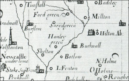
It is interesting to note that Hulton was connected with Cobridge, known then as Rushton, even before the monks arrived. The Domesday Book notes that Lord Robert was the owner of Heltone and Rushton together.


'Land of Robert of Stafford.....'

RUSHTON  [RISCTONE]   
HULTON
[HELTONE]   

Robert also holds the third part of 1 hide in HULTON and RUSHTON. Wulfgeat holds from him. He held it himself before 1066. Land for 3 ploughs.
            3 villagers and 3 smallholders with 1 plough.
            Woodland 1 league long and ½ wide.
Value 10s.


“The monks were serious farmers operating almost on an industrial scale” says Steve. “Throughout the period from the 13th through the 15th centuries it would have been commonplace to see them walking from the abbey over the ridge calling at the hamlets of Birches Head and Sneyd Green where they possibly traded with the villagers before arriving at the farms in Cobridge. No doubt the villagers got to know them quite well.”

I’m keen to retrace the steps of these white monks, so called because of their identifiable hooded clothing. I’m also eager to meet people who live along the way to gauge their knowledge of the importance of their neighbourhood; residents like Potteries’ comedian Pete Conway whose house faces the junction of Chorlton Road where the monks turned to negotiate the climb to the ridge of Sneyd Green.

“I probably did realise I was living on a historic road,” says Pete. “But you don’t think about how much history is on your doorstep until someone tells you about it. Just think all those white-cloaked monks passing by my front door. I read that Hanley was just a sloping field in those times so the bright lights of Cobridge would have been a big pull. How strange. They’d probably call in at the Sneyd Arms on the way for a flagon or two; break the day up a bit. I don’t think I’d fancy being a monk myself, especially one of those silent ones. I’d crack a gag and nobody would laugh. I think I’m more of a black monk type any way, a sort of Rasputin kind of monk, that’s me.”
 

more on Hulton Abbey & Rushton Grange


25 August 2008


click the "contents" button to get back to the main index & map
next: the monks and Sneyd Green
previous:
Dalehall, Burslem