The Geography
of the Potteries (Stoke-on-Trent)
![]()
![]()
![]()
![]()
|
|
|
As it travels through the city the River Trent is
only 2-3ft deep and 4-6ft wide.
The Trent rises
to the north-west of Stoke-on-Trent between Biddulph and Mow Cop at about 700 feet above sea level. The stream
almost immediately, passes into Knypersley Pools, where several streams unite,
with the surplus water proceeding from Biddulph Moor. |
|
|
|
The Potteries lie in a shallow depression on the
south west edge of the Pennines. On the northwest side of the county of
Staffordshire an elevated ridge continues past
Cloud Hill and over Congleton Edge and Mow Cop, and the elevation in many
places is over 1,000 feet above the sea.
Mow Cop is half in Staffordshire and half in Cheshire. At nearly 1091ft (almost
335 metres) above sea-level.
The highest point in the city is Goldenhill,
north of Tunstall, at 700ft above sea-level. The eastern part of the borough of Burslem lay along a north-south ridge between 600 and 700 feet above sea-level. From this ridge two spurs slope westwards to below 400ft, with Burslem on one spur and Cobridge on the other. Middleport is about 420 ft above sea-level. Hanley encompasses a large change in height from 400ft along the route of the Trent, on the north-east, to over 600ft on the Birches Head side of the town. At nearly 600 feet above the sea level, Hanley is accounted one of the highest market towns in England. Etruria canal junction is 408ft above sea level. Stoke town, around the River Trent and Fowlea Brook area is below 350ft but it rises steeply to over 525ft around Penkhull and Hartshill. In the northern part of Fenton there is open country which rises to over 600ft. In the south, below Grove Road the land rises to 500ft. Newcastle-under-Lyme is situated on a ridge to the north-west of the city of Stoke-on-Trent and stands at about 500ft. The pithead wheel at Apedale Country Park near Newcastle stands 750 feet above sea-level. |
|
|
||
|
| Potteries
and Churnet Valley: Characteristics at the end of the 20th Century. |
|
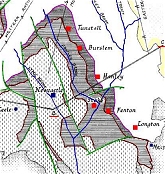
| Geology
of North Staffordshire: Showing coal and clay deposits, faults and waterways.
|
|
| Evidence
of subsidence in Stoke-on-Trent There is large scale subsidence in the city - equivalent to that experienced in earthquake zones. This is caused by the collapse of mining workings.
|
|
| Urban
Structure of Stoke-on-Trent: The City of Stoke-on-Trent is formed from an amalgam of towns and villages that have expanded and merged.
|
|
| Townscape
Interest: List of all areas of interest in and around the city.
|
![]()
questions/comments/contributions? email: Steve Birks
![]()
![]()
![]()