|
Where is Hanley?
In the
late seventeenth century, Hanley consisted of two small hamlets
known as Hanley Upper Green (or just Upper Green) and Hanley Lower
Green (or just Lower Green).
Upper
Green at the junction of Town Road and Keelings Road and Lower Green
where Market Square is today.

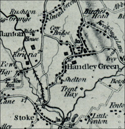
Extract from William Yates
1775 Map of Staffordshire
- showing Handley Green and Shelton as two distinct settlements
- click map for larger
area of map -
The
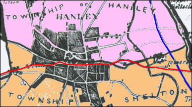
dividing line between Shelton & Hanley:
Stafford Street was the dividing line between
the townships of Hanley & Shelton, so Pall Mall & Piccadilly lay in Shelton
as did large and important buildings such as the town hall in Albion Street,
Bethesda Methodist chapel and the library & Museum.

Townships of Hanley &
Shelton in 1842
- click map for larger view -
The
development of Hanley:
Hanley existed as a vill in the early 13th
century.
In the early 18th century it was still 'a humble
collection of dwellings' which lay chiefly around Upper Green (at the
junction of Keelings Lane and the present Town Road), and Lower Green
(the later Market Square). The whole formed 'two small villages, half a
mile apart'.
Hanley Green as an alternative name to
Hanley was in use by the end of the 16th century, and its use still
lingered in the middle of the 19th century.
By 1775 (see the Yates map) the built-up area had spread
westwards into Shelton township and there was continuous building along
what are now Town Road, Old Hall Street, Albion Street, and Marsh
Street.
The growth of the town is reflected in the building of
the church in 1738, its extension in 1764, and its rebuilding in
1787–90. By the 1790's Hanley, though still smaller than
Burslem, was 'an improving and spirited place'; it was, however, 'built
so irregularly that, to a person in the midst of it, it has scarcely the
appearance of anything beyond a moderate village; yet if the houses had
been properly joined together, it would not only make a capital town but
a well-built one'.
A History of the County of Stafford:
Volume 8
|
![]()