Hanley - Stoke-on-Trent
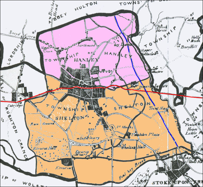
The 1842 map
below shows the two townships of Hanley and Shelton
In those days Shelton was the much bigger township
The dividing line was present day Stafford Street
(the red line as it passes through the built up area)

Hanley and Shelton from 1842 map of the Borough of Stoke-upon-Trent by Michael
Scott
(from Ward's book of the same name)
Blue line
is the present Leek Road, running from
Stoke church (St. Peters) through Joiners Square
and Ivy House on towards Milton.S
Red line is Victoria Road from Fenton
through Joiners Square up Lichfield Street,
then Stafford Street and up Waterloo Road to Cobridge.
![]() on Hanley Lower Green
on Hanley Lower Green
![]() on the Township of Hanley
on the Township of Hanley
Hanley and Shelton were incorporated in 1857. becoming the Borough of Hanley, a name which means 'place at the high clearing'.
| FROM PIGOT'S TYPOLOGY OF ENGLAND IN 1841 - Staffordshire and the Potteries | |
The church, or rather chapel of ease, is a
commodious structure of brick, erected in 1788, with a square tower one
hundred feet in height, containing a fine set of bells; the living is a
perpetual curacy, in the patronage of the trustees of the chapel.
Dissenters of various denominations have numerous places of worship here;
and there are British and national schools, well supported by voluntary
contributions.
SHELTON
is a township in the parish of Stoke, contiguous to Hanley, of which
indeed, it forms an important portion, and its manufactures and police
regulations are similar to those of that town. Shelton forms part of the
borough of Stoke; and is the honour of Tutbury, within the jurisdiction of
a court of requests held at the latter town, every third Tuesday, for the
recovery of debts under forty shillings. Extensive gas-works are in this
township, which also contains some valuable charitable scholastic
institutions.
|
|
| From History, Gazetteer and Directory of Staffordshire, William White, Sheffield, 1851 | |
|
|
|
![]()
Questions, comments, contributions? email: Steve Birks