Streets of Stoke-on-Trent | Glebe Street |
Glebe Street, Stoke,
Stoke-on-Trent
![]()
Streets of Stoke-on-Trent | Glebe
Street |
![]()
![]()
| Index of all Stoke Streets |
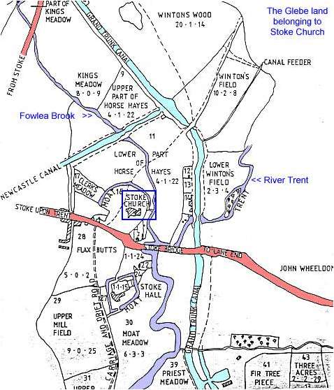
The Glebe Land belonging to Stoke Church

The map below shows part of the glebe estate, land belonging to the church. This estate comprised over 150 acres with a third of the land in the township of Penkhull, a third in Shelton (north of the Fowlea Brook) and a third in Fenton (east of the River Trent).
The church and the rector's house (Stoke Hall) stood on moated sites which provided protection not only from attackers but also from the river which periodically flooded the meadow land in the valley bottom.
This map is undated but it is between 1800 and 1826. 1800 is when the Newcastle Canal (shown on the map) was completed and 1826 which is when work on the new church was started. The streets around the new church (Glebe Street, Wharf Street and Brook Street) were laid out in 1830 and are also not shon on this map.
The Glebe Land belonging to Stoke Church
![]()
![]()
![]()
![]()
Did you live in this street or
area?
questions/comments/contributions?
email: Steve Birks