| Pall
Mall, Hanley
As early as 1818 Pall Mall existed as New Street,
Shelton.
Although now a
desolated street at one time it was a busy place with a large number
of public buildings.......The Free Library, the North Staffs.
Technical and Art Museum, the Government School of Art, the
Potteries Mechanics’ Institution, and the Theatre Royal were all situated
in Pall Mall.

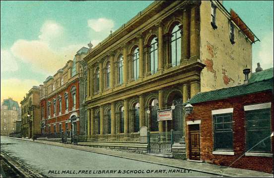
This picture
looks up Pall Mall towards Albion Street
the Town Hall can be seen on the left of the picture at
the very end of Pall Mall
On the right the first large imposing
building was the Museum and further up the road was the free public
library. Both these buildings were demolished in the early 1970's.

|
The 'London' streets of Hanley
"In Whites
Directory of 1834 for Staffordshire, Hanley was
described as a large modern town, the largest in the
Potteries and second in Staffordshire only to Wolverhampton,
its streets were spacious and well-paved, its houses were
neat and some of them were, like the public edifices,
elegant. Small wonder then that this capital town of the
whole Fowlea Valley should name a little group of its new
streets after those of London. So we have Cheapside,
Piccadilly, and Pall Mall, in a naive apeing of a
foppish. distant area by people who have rarely understood
just how proud they ought to be of themselves."
"Portrait
of the Potteries" Bill Morland |
|
Pall Mall
& Piccadilly lay in Shelton.....
|
The dividing line between Shelton & Hanley:
Stafford Street
was the dividing line between the townships of Hanley & Shelton,
so Pall Mall & Piccadilly lay in Shelton as did large and
important buildings such as the town hall in Albion Street,
Bethesda Methodist chapel and the library & Museum.
In
the first third of the 19th century the ground plan of the
present town-centre, including the area round Piccadilly and
Pall Mall (in Shelton Township), was completed.

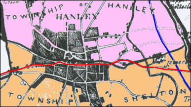
Townships of
Hanley & Shelton in 1842
- click map for larger
view -
Pall Mall and Piccadilly can be
located by the X shaped streets
in the lower section of the map

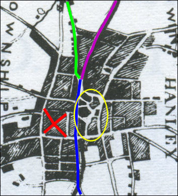
Hanley town
centre from an 1842 map
The red cross marks the position of Piccadilly and Pall Mall
Blue line is Stafford
Street.
Purple line is Bryan Street.
Green Line is Hope Street.
The yellow oval locates the main squares and open areas.
Everything to the
left of Stafford Street was in Shelton and to the right in
Hanley.
|
From: A History of the County of
Stafford: Volume 8 (1963)
|