|
A traveller in 1750 walking the back lanes
through the fields from Handley Green (Hanley) to Stoke Parish Church
would have had a wholly different view. As he drew level with Shelton
Farm, the last vestiges of which would later be known as Mayer's Field
with its attendant abattoir, he would continue south down the gentle
slope of Stoke Fields along the farm track later to become Victoria (and
later still College) Road.
|

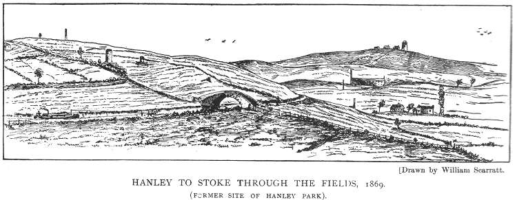
This drawing from a book written in 1906 by William Scarratt
called "Old Times in the Potteries" illustrated the area
called 'Stoke Fields' which was purchased to build Hanley
Park.
A footpath from Stoke to Hanley is running diagonally across
the picture and the path crosses the Caldon Canal over the
bridge. This area was described:
"Down Stoke
Fields were a few whitewashed huts with patches of garden.
The Victoria Road bridge existed, but for the use of the
farm only. The one to the left of the park pavilion was the
one on the Stoke Fields footpath. Shardruck, mounds and
ventilating shafts were far more plentiful than houses." |
Crossing the boundary between Shelton Farm
and entering the Parish Glebe Land of Winton's Wood, he would see
stretched out in front of him, the broad, shallow valley of the River
Trent, the course of which lay some few hundred yards to the east beyond
Leek Road at Trent Hay Farm, the smaller Fowlea (or Foulhay) Brook
running south from Linehouses to join the Trent a mile away near the old
Derby to Chester Roman Road, Rykeneld Street.
The River Trent rises some 900 feet above
sea level, under the shadow of Lask Edge on Biddulph Moor 9 miles to the
north, drops 500 feet in that distance, and then continues south,
sweeping round to the north on its slow 150 mile journey to join
the Humber near Scunthorpe, almost at sea level. The 9th Century
stone-built Parish Church of St Peter ad Vincula lay just to the north
of Rykeneld Street, with the Rector's house Stoke Hall across
the road to the south.
The dilapidated Parish Church which
had been altered and enlarged many times during its long life was
becoming ruinous and like Stoke Hall stood on a moated site as a defence
against the periodic flooding of the nearby river. The traveller would
see a few thatched cottages in the fields with here and there a
small coal pit, but the most significant man-made feature in the
landscape was the church, with the nearest hamlets at the ancient
hill-top settlement of Penkhull to the southwest, and further down the
Trent at Boothen. Our traveller could have turned onto another farm
track, which later became Cauldon Road, and then south onto yet
another rough track ( later Boughey Road ), before completing the last
half mile to the church, crossing the Fowlea Brook by means of a small
cart bridge on the way.
|

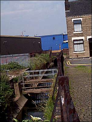
"Fowlea by name and
foul by nature"
The
Fowlea brook (2000) as it runs at the bottom of
Leason Street in Stoke.
On the left the brown building is
part of the Spode factory and in the middle the
blue building is anindustrial electrical factory
on Elenora Street.
The Fowlea Brook runs through a culvert under
Elenora Street
|
The landscape was generally flat and
undulating with a trend to the south; the land itself was not of the
best agricultural quality, being poorly drained and with deposits of
coal and clay near the surface. He would have seen higher ground to the
south and east across the river, at Fenton Low (Berryhill) and Great
Fenton (Mount Pleasant).
Horse drawn traffic:
When he left the Handley Green to Stoke
road at Shelton (Rykeneld Street), he would have been aware of the
constant horse drawn and pack horse traffic plodding in both
directions, carrying out finished pottery ware from, and bringing in
foreign clay and flint to the potteries at Burslem and elsewhere. The
nearest navigable waterway to the east was the Trent at Willington near
Burton, which having collected water from various tributaries along
the way, was at that point deep enough for substantial water-borne
transport. It was to this location that the land traffic from the
potteries was bound, for down the river lay the port of Hull and the
German Ocean, an outlet for the ware and an entry point for the imported
clay and flint, and the return road journey to the Potteries.
There should be no illusion that the
overland journey to the Trent at Willington was easy. The roads were
roughly surfaced, dusty in summer and sometimes impassable in winter.
However the journey from Burslem northwards was far worse. The direct
route through the pottery hamlets was, according to a Petition
presented to Parliament, ..so very narrow, and foundrous as to be
almost impassable for carriages, and in the winter almost so even for
pack-horses. The better, alternative route lay through the Loyal and
Ancient Borough of Newcastle under Lyme, but was double the distance and
subject to Newcastle's Tolls.
The main northerly destination for finished pottery ware, was the port
of Liverpool, from where Josiah Wedgwood had already begun an export
trade. The overland route extended as far as the River Weaver at
Winsford, where water transport was available, connecting with the River
Mersey and the port of Liverpool. Similar to the eastern route to and
from Hull, the return journey brought in clay , flint and Cheshire salt
for the glazing process.
Turnpike roads:
In 1762 a large body of potters which included Josiah Wedgwood,
petitioned Parliament for the authority to construct, widen and
operate a Turnpike road from Red Bull at Lawton, Cheshire to Cliff Bank,
Staffordshire (possibly Hartshill Bank, Stoke) where the non-Turnpike
road from Burslem, Hanley Green and Shelton joined the Newcastle to
Derby Turnpike, thus creating a continuous, better standard road from
north to south through the potteries. Josiah Wedgwood gave evidence to a
Parliamentary Committee to this effect in 1763.
The Loyal and Ancient Borough, well used to
receiving income from travellers through the town, objected strongly to
this threat to their economy. It appears that a compromise was struck
and the ensuing Act for the time being, permitted the new road
only south as far as Burslem. The historical antipathy between
Newcastle and the Potteries was apparently alive even then. However,
although the principle of improved road communication had been
established and more improvements were to follow, the far-sighted
Josiah Wedgwood in 1765 met James Brindley the canal engineer at the
Leopard Inn in Burslem and a new era began.
Population:
At this time the population of the
Potteries Townships would have been about 7,500 souls, with Hanley and
Shelton accounting for about 2,000.
  
next: canals
previous: the very early years - the times of the Romans and Normans
|
![]()
![]()
![]()