|
Lane Delph
- 'following Roman Road is a route back in time'
  
click the "contents"
button to get back to the main index & map
next: Lower Lane
previous: The Foley
|
Historian Fred Hughes writes....
Tracing the old Roman road into Stoke-on-Trent is pretty
straightforward until you reach Lane Delph.
If you're wondering where Lane Delph is, it's at the end of King
Street, Fenton. Over the years, many intercepting roads have so obscured
the old Roman Road that it can now only be followed with difficulty.
Local writer Alan Myatt says: "Some years
ago, I drew a template over a modern OS map and saw that the Roman Road
left King Street past the Angel Inn and into Park Road.
"Then it went through Hitchman Street and
William Street and into the grounds of the Sixth Form College. From
here, the line passed Stoke Station, then through Wolstanton Marsh and
Golf Club into Chesterton and Apedale, where the garrison was based. The
thing that really interested me was that until you get to Fenton, the
Roman Road had always been clearly in use. But from then on, it had
literally become extinguished."
This is quite an impressive observation. And it indicates how
spectacularly industry has changed the landscape of Stoke-on-Trent over a
relatively short period of 300 years.
If we look at Alan's map and remove the built environment, it's easy to
see that when the Romans passed this way, very little existed other than
the Trent tributaries flowing through woodland from the outskirts of the
Moorlands.
Alan adds: "If you want to see the road as the Romans might have seen
it, it's worth a climb to Fenton Park where the
telecommunications mast is. Here you are surrounded by wild fields. Block
out all signs of human enterprise and you're back nearly 2,000 years."
He's right. High on Fenton
Park I can see the line of the road back to Draycott. And in the opposite
direction, there is the headland of May Bank with the landmark Wolstanton
church on the ridge before the skyline dips into the Apedale valley. And
below me is the last bit of road recognisable from Roman times. |
Historian Steve Birks says: "Lane Delph was one of the earliest
populated areas in Fenton and home to a number of early pottery families.
"As a result of the growth of industry, there were, by 1775, three
main centres of population in this district: Great Fenton, formerly
Fenton Culvert; Little Fenton, and Lower Lane and Lane Delph. Fifty
years later, Lane Delph was still one of the largest centres continuing
to grow in buildings and population throughout the early 19th century.
The heart of Lane Delph lay along the main road and around Duke Street
and China Street."
These days, evidence of domestic occupation on this side of King Street
is buried beneath industrial residue, while the community around Fenpark
Road still has rows of Victorian terrace streets.
Jane and Mick Lockett own M&J News in King Street.
"We've been here 18 months," says Jane. "We chose this business because
it was in a thriving area. In fact, more houses are being built around
here all the time. Mind you, I never guessed we stood on a Roman Road. It
might be worth looking at as a publicity angle."
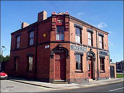
the Angel Inn - Park Road
Lane Delph starts with a pub, the Miners Arms, and ends with one
-the Angel in Park Road. This late Victorian hostelry once stood next to a
Mason's pottery. Interestingly, the Masons called their works Minerva
after the Roman goddess for arts and crafts. Before its demolition in
2001, it was owned by Coalport, and new houses now occupy the site,
bringing more business for Jane and Mick.
On the other hand, being a publican is harder than it's ever been,
according to the Angel's landlord Michael Powell.
"The smoking ban is the latest in a series of issues that have
changed the way we use pubs and treated them as community centres," he
says. "The future of traditional pubs has become very insecure. But we
do all right for the moment."
The Angel stands on the brow of a hill looking along the Roman Road
towards Chesterton. It's easy to imagine the Victorian pub as a Roman
tavern with Legionaries pausing for refreshment on their journey.
But what is the origin of Lane Delph's name?
|
"Delph has references to clay pits or quarries
- it was rural and rugged," says Steve. "The expression 'drowned in a
delph' was used to certify the cause of death in a number of parish
records. It was also the birthplace of Josiah Spode.
"But Miles Mason was the important figure here. An
account i 1829 refers to a large number of new houses for the working
classes, more than likely built for the Masons' workforce. Charles and
George Mason, sons of Miles, established a regular shambles market which
was very popular.
"Only a few years later, historian John Ward was
referring to the community as Middle Fenton. He explained it was to
replace the ancient, but discarded and 'inelegant' name of Lane Delph,
which is a shame really, because Lane Delph sounds much better. Ward
insisted though that the new name gave the location the character of the
respectable small town it has grown into."
In 1843, the local manufacturers decided that a
speedier route to Hanley was needed so the old Roman road was abandoned
and the new Victoria Road was built.
"The new road was set for speed and to save going
into Stoke to get Hanley," says Steve. "It drove across Fenton Low, over
the Trent by a farm called Trent Hay, through Joiners Square and up the
hill into Eastwoood finishing by the Albion Inn. And, of course, this
is the Victoria Road we so love to hate these days."
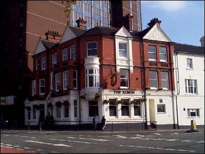
The Albion Hotel - Hanley
|
So this is Lane Delph,
lost among one of the city's busiest intersection. And yet there are few
similar places in the Potteries that resonate with the past more than this
formless a forgotten hamlet.
 on Lane
Delph
on Lane
Delph
next week: Lower Lane
click the "contents"
button to get back to the main index & map
next: Lower Lane
previous: The Foley
|