![]()
Josiah Spode II (1754-1827) and The Mount Estate (Penkhull)
![]()
![]()
The extent and value of Penkhull Farm
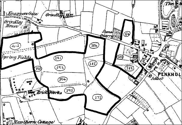
The map shown below is an extract from George Lynam's Map of the Parish of Stoke-upon-Trent (1848) and shows the land attached to Penkhull Farm rented by Josiah Spode from the Alsager family.
The field numbers have been added to the map and relate to the survey of the landed property in the parish of Stoke-upon-Trent carried out by Charles Heaton in 1827.
The extract from the survey below gives the names of the fields, the area (in acres, roods and perches) and the annual value of the land (in Pounds, shillings and pence).
NOTE:
acre - measure of land, 4,840 sq. yds., 0.405 ha. [Old English]
rood - quarter of an acre. [Old English]
perch - measure of length, esp. for land, of 5½ yards. [Latin pertica pole]
PROPRIETOR: Late Misses Alsager OCCUPIER: Josiah Spode Esq. Numbers Description of Property A R P £ s d 381 Homestead &c - 2 4 11 0 0 383 Stackyard and croft 1 3 20 4 13 9 382 Barnfield and Little croft 4 1 15 9 11 1 54 Townsend 3 1 15 8 7 2 386 Flat 4 3 38 9 9 6 385 Thistley or White Hough 5 1 24 28 18 3 373 Eight acre field 9 0 9 395 Little Cliff 4 3 5 38 19 0 394 Long wheat Cliff 7 2 26 391 Broomy or Clover Cliff 5 2 6 392 Cliff meadow or Rough Cliff 4 2 39 393 Slang or Little meadow 1 0 30 13 6 10 413 Great or Little Hordern 12 0 25 436 Brook or red meadow 3 2 15 8 19 8 Totals:
69 1 21 133 5 3
Extract from George Lynam's Map of the
Parish of Stoke-upon-Trent (1848),
showing the land attached to Penkhull Farm.
![]()
questions/comments/contributions? email: Steve Birks