In particular the
walk focuses on the role played by two families: the Wedgwood family of the
Big House and the Wood family of Fountain Place, Burslem.
In particular the
walk focuses on the role played by two families: the Wedgwood family of the
Big House and the Wood family of Fountain Place, Burslem.
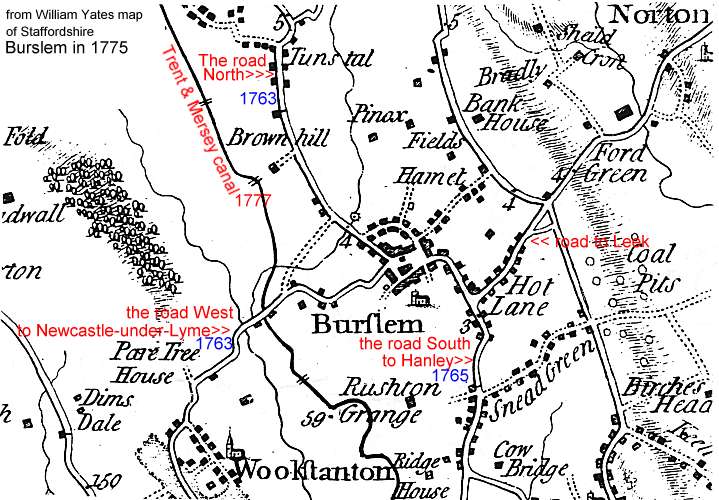
The map below, an
extract from William Yates's Map of Staffordshire, shows the town and its
vicinity in 1775.
The new turnpike roads
promoted by Josiah Wedgwood and his fellow pottery manufacturers can be
easily located on the map. The road north, turnpiked in 1763, ran down
Westport Road to Tunstall to join the main road at the Red Bull in Lawton.
The road west to
Newcastle-under-Lyme, also turnpiked in 1763, originally ran down Packhorse
Lane. By 1812 it had been replaced by the present line of road and in 1828
the Turnpike Trust sold most of Packhorse Lane to Enoch Wood who
incorporated it into his factory.
The road south to Hanley,
turnpiked in 1765, ran down Nile Street. Its replacement, the present
Waterloo Road, was not built until 1814-17.
The road east to Leek ran via
Hot Lane. Moorland Road was built in 1820 to provide a more direct access to
Smallthorne and the east.
The thick black line running diagonally across the map is the Trent and Mersey
Canal. Begun in 1766 when Josiah Wedgwood cut the first sod at Brownhills it
was nearing completion in the mid 1770s. Burslem Branch Canal was built in
1805 after a campaign led by Enoch Wood.
The Canal Company built a new road, Navigation Road, from Burslem Wharf to St
John's Square, along which they ran a horse-drawn tramway to the town centre (see
1832 map). The two maps show how the town grew and
developed between 1740 and 1832 as a result of the improvement in the
transport system.
The 1740
map
should be treated with a little caution. It probably began as a plan of the Over House
Estate while it was in the ownership of Katherine Egerton. The plan was
subsequently added to, from memory, at a later date in the 18th century. All
the other versions of this map are re-workings of the copy produced by William
Heaton in the early 19th century.