![]() »
History | » Formation of the
City
»
History | » Formation of the
City
|
|
|
|
|
|
The Making of Stoke-on-Trent: From Six Towns to
the City
|
Stoke-on-Trent is one of England's most distinctive cities. Unlike most towns and cities, which developed around a single historic centre, Stoke-on-Trent was created from the union of six separate towns that had grown side by side across the North Staffordshire coalfield. Each town had its own character, industries, local government and identity, yet together they formed the world-famous Potteries.
This page traces the story of how a group of medieval settlements evolved into the modern city of Stoke-on-Trent. It explores the origins and growth of the six towns, the movement for federation, the creation of the city, and the later boundary disputes and expansions that helped shape the Stoke-on-Trent we know today.
|
|||||||||||||||||||||||||||||||||||||||||||||||||||
| 1. Formation of the urban landscape: |
|
|
|
|
|
|
|
1700-1850
Industry and Urban Expansion
|
| 2. Failure of Fragmentation: |
| Population
growth
Definitions of town boundaries were not consistent. In some cases, figures for individual towns include surrounding townships or developing industrial districts that were closely associated with them. For example, Hanley figures often include the adjacent settlements of Shelton and Etruria, reflecting the continuous urban development of the area rather than strict administrative boundaries. Where possible, the figures have been standardised for comparison, but differences in source material mean that long-term trends are more reliable than precise year-to-year totals. |
| 1701 | 1738 | 1801 | 1821 | 1841 | 1851 | 1861 | 1887 | 1893 | 1901 | 1907 | |
| Tunstall | 2,622 | 9,566 | 11,150 | 14,244 | 19,492 | 27,850 | |||||
| Burslem | 1,800 | 10,176 | 16,091 | 18,000 | 22,327 | 38,000 | 40,000 | ||||
| Hanley | 12,712 | 20,564 | 46,636 | 48,361 | 54,846 | 61,599 | 86,360 | ||||
| Stoke | 1,600 | 3,969 | 9,649 | 11,390 | 30,458 | 35,000 | |||||
| Fenton | 5,348 | 13,830 | 23,000 | 25,000 | |||||||
| Longton | 7,100 | 12,345 | 15,149 | 16,690 | 35,000 | 37,000 |
|
According to the official 1911 Census, the newly formed County Borough of Stoke-on-Trent recorded a population of 214,776, making it one of the largest county boroughs in England at the time. Following the boundary extension of 1 April 1922, the borough increased in size to incorporate surrounding districts. Because this change occurred between national censuses, the most reliable comparative figure is provided by the 1921 Census, which recorded a population of approximately 240,440 within the enlarged borough area. Estimates for the post-extension period therefore place the population of Stoke-on-Trent at around 240,000–245,000 in the early 1920s. When city status was granted on 5 June 1925, contemporary records give a population of approximately 294,000, reflecting continued urban growth during the inter-war period. By the 1951 Census, the population of the City of Stoke-on-Trent was 275,115.
|
|
|
|
Local Government and
Rivalries
|
| Civic status of the towns before federation |
| Town | Borough Status | Character | comments |
| Hanley | 1857 Municipal Borough |
Commercial centre | In 1857 Hanley and Shelton were incorporated as the Borough of Hanley. |
| Hanley | 1889 County Borough |
Largest and most powerful commercial centre | Hanley was large enough to separate from the main county council of Staffordshire. It became a independent County Borough, meaning it ran all of its own local services. |
| Longton | 1865 Municipal Borough |
Industrial town | In March, 1865 Longton and Lane End were incorporated as the Borough of Longton. |
| Stoke-upon-Trent | 1874 Municipal Borough |
Administrative and railway centre | In January 1874 the towns of Stoke, Penkhull and Boothen were incorporated as the Borough of Stoke-upon-Trent. |
| Burslem | 1878 Municipal Borough |
Mother Town of the Potteries | In June 1878 Burslem was incorporated - although not the first of the six towns to be incorporated Burslem was the largest town in the Potteries for many years. |
| Tunstall | 1894 Urban District |
Northern town, mining and pottery |
Tunstall
& Fenton - Did not have charters or mayors. |
| Fenton | 1894 Urban District |
Smallest of the Six Towns |
|
|
|
The
Long Road to Federation (1888–1910)
|
| 3. Creation of the Modern City: |
| Federation achieved - Creation of the County Borough |
|
After more than two decades of discussion, negotiation and political campaigning, agreement was finally reached. On 31 March 1910 the towns of Burslem, Hanley, Longton, Stoke-upon-Trent, Tunstall and Fenton were united to form the County Borough of Stoke-on-Trent.
|
|
Not yet a city
|
|
|
|
Federation - further Reading » The story of federation is covered in much greater detail in the Federation of the Potteries section, including the various proposals, campaigns, political figures and public debates that led to the creation of Stoke-on-Trent in 1910. |
|
|
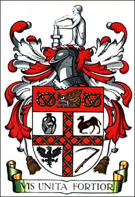
| The Official
Branding of the United Six
Towns |
|
|
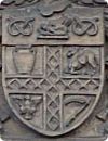
When the six pottery towns—Burslem, Fenton, Hanley, Longton, Stoke-upon-Trent, and Tunstall—federated into a single county borough, the new council needed a legal symbol to unite them.
“Vis unita fortior” The new civic identity of Stoke-on-Trent was also reflected in its motto, “Vis unita fortior”, meaning “United strength is stronger.” The phrase captured the central idea behind federation: that the six towns, each with its own traditions and identity, were stronger together than apart. It became a lasting expression of the borough's foundation and purpose, symbolising the unity that had made both federation and later city status possible. |
|
|
|
|
|
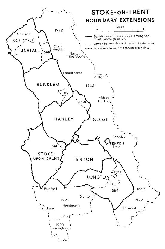
| The 1922 Extension of the Boundaries
|
|
Source: British History Online (Victoria County History, Staffordshire, Vol. 8, pp. 259–271). https://www.british-history.ac.uk/vch/staffs/vol8/pp259-271
|
Although federation had united the Six Towns in 1910, the new county borough did not include all of the communities that were economically and socially linked to the Potteries. Industrial growth had spread beyond the borough boundaries, and many neighbouring districts were closely connected through employment, housing and transport.
Not all proposals for expansion were accepted, and debate continued over the future boundaries of the borough. Questions remained about whether neighbouring communities, particularly Newcastle-under-Lyme and parts of Wolstanton, should eventually become part of Stoke-on-Trent. The 1922 extension represented the second major stage in the creation of the modern city. Federation had united the Six Towns; boundary enlargement brought many of the surrounding communities into the borough and laid the foundations for further expansion in the decades that followed.
The 1922 change wasn’t just growth — it was the point where Stoke-on-Trent began to function as a full metropolitan district rather than a tight six-town core.
Population changes Pre-federation estimates suggest that the Six Towns had a combined population of just over 250,000 by the early twentieth century. However, the 1911 Census, the first official enumeration after federation, recorded the population of the newly formed County Borough of Stoke-on-Trent as 214,776. The difference reflects both the use of different statistical methods and the standardisation of boundaries under the new unified authority. After the 1922 additions (including places such as Trentham, Blurton, Goldenhill, Newchapel and surrounding districts), the population increased to approximately 240,000–250,000 |
|
|
|
1925
- City status granted
|
Federation → Extension → City
Status
there were three separate stages in the making of Stoke-on-Trent
| Date | Event |
| 31 March 1910 | Federation creates the County Borough of Stoke-on-Trent |
| 1 April 1922 | Boundary extension |
| 5 June 1925 | City status granted |
|
|
|
1930s
- The Newcastle Boundary Disputes
|
|
Conclusion: A City Defined by Six Towns
|
Sources and Further ReadingPrimary and Reference Sources
Key Historical References
Related Pages
|
|
|
||||
|
Further
reading » |
||||
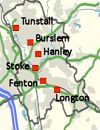
| The Six Towns of the Potteries | Timeline of Stoke-on-Trent History | Domesday Book and North Staffordshire | The Federation of the Potteries | The Coat of Arms of Stoke-on-Trent |
 |
 |
 |
 |
 |
| Explore the history and development of Burslem, Hanley, Longton, Stoke-upon-Trent, Tunstall and Fenton. | A chronological guide to key events from Roman times to the present day. | Some of the earliest recorded references to settlements within the area that would became Stoke-on-Trent | The campaigns, debates and personalities that led to the creation of Stoke-on-Trent in 1910. | How the heraldry, motto Vis Unita Fortior, and civic symbols reflected the union of the Six Towns. |
|
|
||||
|
|