Maps of Stoke-on-Trent & North Staffordshire
![]()
Maps of Stoke-on-Trent &
North Staffordshire
![]() | main
map index |
| main
map index |
Extract from William Yates 1775 Map of
Staffordshire
- showing the Lane Delph of Fenton area
Extract from William Yates 1775 Map of
Staffordshire - showing the Lane Delph area
mills are shown as [![]() ]
]
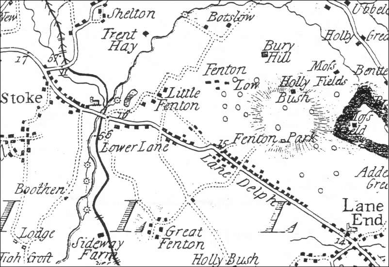
The map above, is an extract from William Yates’s Map of Staffordshire, shows the town of Fenton, recorded on the map as Lane Delph, in 1775.
The road running diagonally across the map was the road from Newcastle-under-Lyme to Uttoxeter turnpiked in 1759.
This road is now known as King Street.
Most of the land north of the road was in the township of Fenton Vivian; the land south of the road in the township of Fenton Culvert. Initially the main settlements were at Great Fenton and at Fenton Park but by the middle of the eighteenth century most of the population lived in houses built along the main road.
A century later John Ward noted c. 1840:
“The houses, manufactories, and buildings, principally stand upon or near the boundary line of the Townships, being dispersed along the main road, between Stoke and Longton, a distance of two miles. They hardly assume the character of a town, but rather present the appearance of three separate villages.”
See more information on the Lane Delph area
|
- take a 'walk' around this area |
![]()
![]() | main
map index |
| main
map index |
updated: 26 Oct 2005