| Districts | Streets | Maps

Stoke-on-Trent Districts: Penkhull

| History of the Hamil of Sneyd |
| aerial photo of Bank Top |
| 1890 OS map of Bank Top |
(The 1890 map takes a minute
 or so to load)


Township of Penkhull with Boothen
1842 map showing the "Township of Penkhull with Boothen"

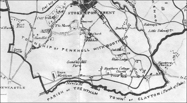
Bank Top is located at the edge of the old Hamlet of Sneyd - Stanfields, Bank House, Hamil and Sneyd Farm can be seen in the centre of the map.

"...the principle messuage in the hamlet in "Bank House," a showy mansion on the summit of the ridge, erected by the Late Mr. Richard Riley, just before his decease in 1828, and is now occupied by Mr. Joseph Twigg."

Ward 'The borough of Stoke-on-Trent' 1842


Twigg, Joseph (1780-1861), colour manufacturer, Burslem

"Joseph Twigg, born in 1780, inherited a colour works at Velvet Croft, Burslem, started by his father, William, on land bought from William Adams.
Joseph Twigg attended Burslem church. He was elected chairman of the improvement commissioners in 1825. He married Ann, daughter of William Adams, on 15 September 1817. They had three sons, William Edward, Joseph and Francis.
The family lived at Bank House, Burslem.
Joseph Twigg died in 1861, his son Joseph continuing the business."

William Edward Twigg was born on 27 Oct 1820 at the Bank House. He was articled to John Ward, the local historian.

Source: 'People of the Potteries', Adams, VCH viii. 


Why the name Riley occurs so often in this area?
In the district of Bank Top we have 'Riley Terrace', 'Rileys' public house and Riley Avenue.
John Ward in his 'The Borough of Stoke-upon-Trent' (1843) records the among the chief proprietors of the land and mixed property .... The Misses Riley..' also '"Bank House,' a showy mansion on the summit of the ridge, erected by the late Mr. Richard Riley, just before his decease in, in 1828.'


Links to photos of Streets in and around the Bank Top area:

High Lane
Bank Top Avenue
Fairway Road
Greenbank Road
Oakville Avenue
Bluestone Avenue
Hamil Road


location and major roads
Bank Top is located on a narrow strip alongside High lane. High Lane runs from Smallthorne roundabout at the junction of Hanley Road, Moorland Road and Ford Green Road - at the other end (after Bank Top) High Lane runs into Chell Heath Road.
High Lane (and Bank Top) are the main route from Hanley to Chell 

Greenbank Road, at one end of Bank Top, runs from High Lane to Tunstall and at the other end of Bank Top, Hamil Road runs down to Burslem.

Bank Top sits on the ridge of a hill - to the west the land falls away very steeply to the town of Tunstall and to the east to Bradeley. Other districts around Bank Top are Stanfield, and Hamil to the west; Chell and Fegg Hayes are to the north.


features on the 1890 OS map
Roads:
This area was undeveloped and on the 1890 OS map there are only two roads running off High Lane, these being Hamil Road running west to Burslem and an unnamed track running east to Hackhouse Wood and Barn Hays.
On the 1925 map Hackhouse Wood had turned into Acres Wood and eventually the unnamed track became Acreswood Road.

Housing:
Housing is sparse with a handful of cottages and only one significant house (Bank House). 
Apart from Bank House the only other named home on the 1890 map was Bluestone Cottage, situated on High Lane opposite Hamil Road. This is now the location of Bluestone Avenue.

Churches:
There are no churches shown on the 1890 map.

Farms:
There are no farms shown in the area of Bank Top. 

Collieries:
From the Hamil Road end on the west side of High Lane (and set back from High lane) three collieries are shown, in order being: Jackfield Colliery, Byker's Colliery and Stanfield Colliery. 
On the east side and bordering on Hamil Road is the Banktop Colliery itself.
All four of these workings were subject to flooding, in or around the 1880's they were closed for this reason, although some were acquired by the Sneyd Colliery Co. 

Railways:
A mineral railway joined the Tunstall Branch of the NSR at Pinnox Junction in Tunstall and ran to High Lane. 

Old Shafts:
In addition to the collieries listed above there are numerous old coal and ironstone shafts shown. 

Mills:
The map shows a flint mill between the Jackfield Colliery and High Lane.


features on the 1925 OS map
Roads:
Development has been taking place since the 1890 map. A grid of streets and terraced houses had been built at the top of Hamil Road - where Jackfield Colliery was situated. One of the streets was named Jackfields Street.

Few other streets had been built - there was a small group around Bank Hall, including Oakville Avenue which had the only semi-detached villas in the area.
Greenbank Road had been built but finished in a field halfway down the hill - it did not yet join Queens Avenue in Tunstall. Cooper Street and Norton Terrace had been built near the top of Greenbank. (now Patterndale Street and Norton Avenue)

On the 1925 map Hackhouse Wood had turned into Acres Wood and eventually the unnamed track became Acreswood Road.

Housing:
Bank House and Bluestone Cottage, situated on High Lane are still the only named houses. Groups of terraced houses are springing up - concentrating around the top of Hamil Road.

Churches:
A Wesleyan Methodist Church has been built opposite the small group of villa style semi-detached houses in Oakville Avenue, near to Bank Hall.

Schools:
An infants school has been built on Jackfields Street and a further school on York Street.

Farms:
There are no farms shown in the area of Bank Top. 

Collieries:
All four of the collieries have closed and an estate of terraced houses has been built on the Jackfield Colliery site (one of the roads is called Jackfields Street).
Bykers and Stanfield Colliery are only a few hollows and old shafts. The Banktop Colliery is the location of a Marl Works. 

Railways:
The mineral railway which appeared on the 1890 map has been removed by the time the 1925 map was published and all that remains is a discontinuous raised strip of land.

Old Shafts:
Very few old shafts are now shown, the few there are being mostly concentrated on the old Bykers Colliery site.

Mills:
No mills remain at the time of the 1925 map.

Recreation:
Bank Hall (which in 1922  was taken over by the Burslem Suburban Club and Institute) now has a bowling green.
Behind the Methodist Church a cricket ground and pavilion was located.
Allotment Gardens are shown on High Lane opposite the large housing estate built on the Jackfield Colliery site and opposite Bank Hall.

Stanfield Hospital:
The isolation of the area was a factor in the building of Stanfield Hospital in 1906, by the 1920s this was being used for consumptives. 


features in 2000
 

St. Werburgh's on High Lane - built 1953

Riley Terrace

1886 houses on High Lane


listed buildings
There are no listed buildings in the Bank Top area.


significant buildings
Few large houses appear in this area. Bank House (or Hall) is an exception, and there has been a house here since at least the early 18th century when a William Stevenson lived there. In 1828 Richard Riley built a "showy mansion on the summit of the ridge", with castellated parapets and corner turrets. This remained a private house until shortly before 1922 when it was taken over by the Burslem Suburban Club and Institute.


questions / comments / contributions? email: Steve Birks