Master Potters in Georgian Burslem (1714-1837)


The Wedgwood Family and Enoch Wood

These pages describe a history walk around Burslem, Stoke-on-Trent. 

The purpose of the walk is to look at the transformation of the town which occurred between 1714 when King George I came to the throne and the accession of Queen Victoria in 1837.

In particular the walk focuses on the role played by two prominant families:  The Wedgwood family of the Big House and the Wood family of Fountain Place. 


Burslem - from William Yates Map of Staffordshire 1775
the dates in blue are when the road was turnpiked (toll roads to raise finances)

This map is an extract from William Yates's Map of Staffordshire which shows the town of Burslem and its vicinity in 1775.

The new turnpike roads promoted by Josiah Wedgwood and his fellow pottery manufacturers can be easily located on the map (shown in orange). 

  • The road north was turnpiked in 1763, it ran down Westport Road to Tunstall to join the main road at the Red Bull in Lawton.

  • The road west to Newcastle-under-Lyme, was also turnpiked in 1763, it originally ran down Packhorse Lane. By 1812 it had been replaced by the present line of road (Newcastle Street) and in 1828 the Turnpike Trust sold most of Packhorse Lane to Enoch Wood who incorporated it into his factory.

  • The road south to Hanley, turnpiked in 1765, ran down Nile Street. Its replacement, the present Waterloo Road, was not built until 1814-17.

  • The road east to Leek ran via Hot Lane. Moorland Road was built in 1820 to provide a more direct access to Smallthorne and the east.

The thick black line running top lift to bottom middle is the Trent and Mersey Canal. Begun in 1766 when Josiah Wedgwood cut the first sod at Brownhills it was nearing completion in the mid 1770s. The Burslem Branch Canal was later built in 1805 after a campaign led by Enoch Wood.
The Canal Company then built a new road, Navigation Road, from Burslem Canal Wharf to St John's Square, along which they ran a horse-drawn tramway to the town centre


location 1: John & Thomas Wedgwood of the Big House
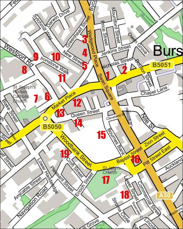


- Map of the walk -


Click the map to go to a location
- or select from the list below -

Locations & photos of the tour 
1 The Big House of Thomas & John Wedgwood, built 1750
2 Red Lion public house and Hamil Road
3 The Over House Estate
4 Wedgwood Place and Georgian houses
5 Wedgwood Street (now New Street), built by the Wedgwood family
6 Enoch Wood's Fountain Place factory & Pack Horse Lane
7 Location of Enoch Wood's home & view over the Fowlea valley
8 Hill Top Sunday School and Wood's Hill Top factory
9 The ragged school for destitute children
10 "The Bowling Green" in High Street
11 The alley from High Street to Market Square & the Town Hall
12 The Mechanics Institution
13 The development of St. John's Square
14 New Church Street (now William Clowes Street)
15 Old Church Street (now Bournes Bank)
16 Burslem National School
17 St. John's Church
18 Thomas Wedgwood's Church Yard Works
19 Navigation Road - the link from Burslem canal to the town centre


Additional notes and maps (which support the tour)

Burslem section of 1775 William Yates map of Staffordshire
1740 town plan of Burslem by William Heaton
1832 map of Burslem by T. Hargreaves. (shows development of roads)
1812 plan of the centre of Burslem, shows new streets & squares
New Town Hall (work started on building in 1761)
Josiah Wedgwood Ivy House Works (1759-62) and the New Market Hall
Josiah Wedgwood Brickhouse (or Bell) Works (1762-1773)
1851 detailed Ordnance Survey map of Burslem town centre
St. John's Church, plan of gallery & schedule of pewholders
1851 detailed Ordnance Survey map of St. John's church
1788 notice from church wardens on Sunday behaviour
1815 notice on 'tippling' (drinking) during working hours
The story of Enoch Wood (1759-1840)
1851 detailed Ordnance Survey map of Wood's factories
Pictures of Enoch Wood's factory in 1843
1878 Ordnance Survey map showing  Wood's grounds & the flint mill
Scriven's 1841 report on working conditions at Wood's Potworks
Burslem 'Hill Top' Sunday School


location 1: John & Thomas Wedgwood of the Big House


This walk conducted by and  based on notes by Andrew Dobraszczyc, (May 2000)
photographs taken by Steve Birks during the walk 

Questions, comments, contributions? email: Steve Birks